Greater Lowell | |
|---|---|
Region of Massachusetts | |
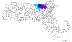
 Red represents the City of Lowell, Dark Blue represents the Greater Lowell area, Light Blue represent the New England city and town area Division Lowell-Billerica-Chelmsford, Purple represents both. | |
 | |
| Coordinates: 42°40′00″N 71°20′00″W / 42.66667°N 71.33333°W | |
| Country | |
| State | |
| Towns and cities | Billerica, Chelmsford, Dracut, Dunstable, Groton, Lowell, Pepperell, Tewksbury, Tyngsborough, Westford |
| Largest city | Lowell, Massachusetts (108,522) (2010 census) |
| Population (2010 census) | |
• Total | 299,550 |
Greater Lowell is the region comprising the city of Lowell, Massachusetts, and its suburbs. These lie in northern Middlesex County, Massachusetts; in the Merrimack Valley; and in southern New Hampshire.
