Back Groter Manchester Afrikaans Gran Manchester AN مانشستر الكبرى Arabic مانشستر الكبرى ARZ Gran Mánchester AST Manchester Raya BAN Вялікі Манчэстэр Byelorussian Вялікі Манчэстэр BE-X-OLD Голям Манчестър Bulgarian বৃহত্তর ম্যানচেস্টার Bengali/Bangla
Greater Manchester | |
|---|---|
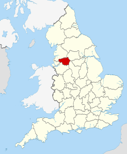
 Location of Greater Manchester within England | |
| Coordinates: 53°30′09″N 2°18′36″W / 53.5025°N 2.3100°W | |
| Sovereign state | United Kingdom |
| Constituent country | England |
| Region | North West England |
| Established | 1 April 1974 |
| Established by | Local Government Act 1972 |
| Time zone | UTC+0 (GMT) |
| • Summer (DST) | UTC+1 (BST) |
| UK Parliament | 27 MPs |
| Police | Greater Manchester Police |
| Ceremonial county | |
| Lord Lieutenant | Diane Hawkins[1] |
| High Sheriff | Lorraine Worsley-Carter[2] |
| Area | 1,276 km2 (493 sq mi) |
| • Rank | 39th of 48 |
| Population (2022)[3] | 2,911,744 |
| • Rank | 3rd of 48 |
| Density | 2,282/km2 (5,910/sq mi) |
| Ethnicity | 2021 census[4] |
| Metropolitan county | |
| Government | Greater Manchester Combined Authority |
| Mayor | Andy Burnham (L) |
| GSS code |
|
| ITL | TLD3 |
| Website | greatermanchester-ca |
| Districts | |
 Districts of Greater Manchester Metropolitan districts | |
| Districts | |
Greater Manchester is a ceremonial county in North West England. It borders Lancashire to the north, Derbyshire and West Yorkshire to the east, Cheshire to the south, and Merseyside to the west. Its largest settlement is the city of Manchester.
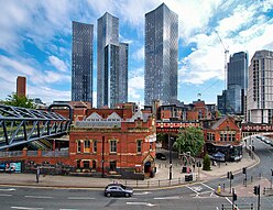
The county has an area of 493 sq mi (1,277 km2)[5] and is highly urbanised, with a population of 2.9 million. The majority of the county's settlements are part of the Greater Manchester Built-up Area, which extends into Cheshire and Merseyside and is the second most populous urban area in the UK. The city of Manchester is the largest settlement. Other large settlements are Altrincham, Bolton, Rochdale, Sale, Salford, Stockport and Wigan. Greater Manchester contains ten metropolitan boroughs: Manchester, Salford, Bolton, Bury, Oldham, Rochdale, Stockport, Tameside, Trafford and Wigan, the councils of which collaborate through Greater Manchester Combined Authority. The county was created on 1 April 1974 from parts of north-east Cheshire, south-east Lancashire, and a small part of the West Riding of Yorkshire.
The centre and south-west of Greater Manchester are lowlands, similar to the West Lancashire Coastal Plain to the north-west and the Cheshire Plain to the south-west. The north and east are part of the Pennines: the West Pennine Moors in the northwest, the South Pennines in the northeast and the Peak District in the east. Most of the county's rivers rise in the Pennines and are tributaries of the Mersey and Irwell, the latter of which is itself a tributary of the Mersey. The county is connected to the Mersey Estuary by the Manchester Ship Canal, which for its entire length within Greater Manchester consists of canalised sections of the Mersey and Irwell.
What is now Greater Manchester was a largely rural area until the Industrial Revolution, when the region rapidly industrialised. The area's towns and cities became major centres for the manufacture of cotton textiles, aided by the exploitation of the Lancashire coalfield. The region was also an engineering and scientific centre, leading to achievements such as the first inter-city railway and Ernest Rutherford's pioneering work on nuclear fission. Since deindustrialisation in the mid-20th century the county has emerged as a major centre for services, media and digital industries, and is renowned for guitar and dance music and its football teams.[6]
- ^ "Appointment of Lord-Lieutenant of Greater Manchester: 28 March 2022". 10 Downing Street. 28 March 2022. Archived from the original on 13 September 2022. Retrieved 13 September 2022.
- ^ "New High Sheriff of Greater Manchester chosen by the Queen". Manchester Evening News. 22 March 2022. Archived from the original on 13 September 2022. Retrieved 13 September 2022.
- ^ "Mid-2022 population estimates by Lieutenancy areas (as at 1997) for England and Wales". Office for National Statistics. 24 June 2024. Retrieved 26 June 2024.
- ^ "Ethnic group". Office for National Statistics. 28 March 2023. Retrieved 23 October 2023.
- ^ "UK Standard Area Measurements (SAM)". Office for National Statistics. Archived from the original on 24 September 2015. Retrieved 28 September 2012.
- ^ Cite error: The named reference
creativewas invoked but never defined (see the help page).


