Back غروفيتون (نيوهامبشير) Arabic قرووتون، نیوهمپشایر AZB Groveton (Nou Hampshire) Catalan Groveton (lungsod sa Tinipong Bansa, New Hampshire) CEB Groveton (New Hampshire) German Groveton (Nuevo Hampshire) Spanish گرووتون، نیوهمپشایر Persian Groveton, New Hampshire HT Groveton (New Hampshire) Italian Гроувтон (Нью-Гэмпшир) Kazakh
Groveton, New Hampshire | |
|---|---|
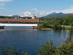
 Covered bridge over the Upper Ammonoosuc River in front of former paper mill in Groveton. The Percy Peaks are in the distance. | |
| Coordinates: 44°35′56″N 71°30′52″W / 44.59889°N 71.51444°W | |
| Country | United States |
| State | New Hampshire |
| County | Coos |
| Town | Northumberland |
| Area | |
| • Total | 2.15 sq mi (5.57 km2) |
| • Land | 2.06 sq mi (5.33 km2) |
| • Water | 0.09 sq mi (0.23 km2) |
| Elevation | 883 ft (269 m) |
| Population (2020) | |
| • Total | 1,068 |
| • Density | 518.45/sq mi (200.19/km2) |
| Time zone | UTC-5 (Eastern (EST)) |
| • Summer (DST) | UTC-4 (EDT) |
| ZIP code | 03582 |
| Area code | 603 |
| FIPS code | 33-32260 |
| GNIS feature ID | 0867268 |
Groveton is a census-designated place (CDP) and the primary village in the town of Northumberland in Coos County, New Hampshire, United States. The population was 1,068 at the 2020 census.[2] It is located at the intersection of U.S. Route 3 and New Hampshire Route 110.
- ^ "ArcGIS REST Services Directory". United States Census Bureau. Retrieved September 20, 2022.
- ^ "Groveton CDP, New Hampshire: 2020 DEC Redistricting Data (PL 94-171)". U.S. Census Bureau. Retrieved November 18, 2021.

