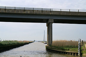
| Haddiscoe Cut | |
|---|---|
 The bridge carrying the A143 over the Cut | |
| Specifications | |
| Maximum boat length | 46 ft 0 in (14.02 m) |
| Maximum boat beam | 18 ft 0 in (5.49 m) |
| Locks | 0 |
| Maximum height above sea level | 0 ft (0 m) (tidal - 3ft rise) |
| Status | Navigable |
| Navigation authority | The Broads Authority |
| History | |
| Original owner | Norwich and Lowestoft Navigation Co |
| Principal engineer | William Cubitt |
| Date of act | 1827 |
| Date of first use | 1833 |
| Geography | |
| Start point | Reedham, River Yare |
| End point | Haddiscoe, River Waveney |
Haddiscoe Cut | |||||||||||||||||||||||||||||||||||||||||||||||||||||||||||||||||||||||||||||||||||||||||||||||||||||||||||||||||||||||||||||||||||||||||||||||||||||||||||||||||
|---|---|---|---|---|---|---|---|---|---|---|---|---|---|---|---|---|---|---|---|---|---|---|---|---|---|---|---|---|---|---|---|---|---|---|---|---|---|---|---|---|---|---|---|---|---|---|---|---|---|---|---|---|---|---|---|---|---|---|---|---|---|---|---|---|---|---|---|---|---|---|---|---|---|---|---|---|---|---|---|---|---|---|---|---|---|---|---|---|---|---|---|---|---|---|---|---|---|---|---|---|---|---|---|---|---|---|---|---|---|---|---|---|---|---|---|---|---|---|---|---|---|---|---|---|---|---|---|---|---|---|---|---|---|---|---|---|---|---|---|---|---|---|---|---|---|---|---|---|---|---|---|---|---|---|---|---|---|---|---|---|---|
| |||||||||||||||||||||||||||||||||||||||||||||||||||||||||||||||||||||||||||||||||||||||||||||||||||||||||||||||||||||||||||||||||||||||||||||||||||||||||||||||||
The Haddiscoe Cut or New Cut is a canal in the English county of Norfolk and in The Broads National Park.[1]). The cut was conceived as a way to provide a more direct route from Lowestoft to Norwich, and was built as part of a larger scheme which included the linking of the River Waveney to Oulton Broad and Lake Lothing. It was opened in 1833, but the new route was not a financial success, and it was sold to a railway developer in 1842. It remained in railway ownership until Nationalisation in 1948, and was damaged by floods in 1953. An attempt to close it in 1954 was resisted by local interests, resulting in it being repaired. It is now managed by the Environment Agency.
- ^ "Introduction". Broads Authority. Archived from the original on 15 May 2020.
