Back Harney Basin CEB Harneyská pánev Czech Cuenca Harney Spanish Bassin de Harney French אגן הרני HE Bacino Harney Italian ハーニー盆地 Japanese Бассейн Харни Russian Lòng chảo Harney Vietnamese
| Harney Basin | |
|---|---|
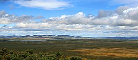
 Harney Basin near Burns, Oregon | |
 The Harney Basin (dashed yellow perimeter) | |
| Floor elevation | 4,111 ft (1,253 m)[1][2] |
| Area | 3,855 km2 (1,488 sq mi) |
| Geography | |
| Coordinates | 43°15′14″N 118°42′54″W / 43.25389°N 118.71500°W |
| River | Donner und Blitzen River; Silvies River |
| Lake | Harney Lake; Malheur Lake |
The Harney Basin is an endorheic basin in southeastern Oregon in the United States at the northwestern corner of the Great Basin. One of the least populated areas of the contiguous United States, it is located largely in northern Harney County, bounded on the north and east by the Columbia Plateau—within which it is contained, physiographically speaking—and on the south and west by a volcanic plain. The basin encompasses an area of 1,490 square miles (3,859 km2) in the watershed of Malheur Lake and Harney Lake. Malheur Lake is a freshwater lake, while Harney Lake is saline-alkaline.[3]
The basin is bounded on the north by the southern end of the Blue Mountains. The ridge of Steens Mountain separates the basin from the watershed of the Alvord Desert to the southeast.[4] No streams cross the volcanic plains that separate the basin from the watershed of the Klamath River to the southwest. The basin includes archeological sites of the Drewsey Resource Area.[5]
- ^ "Query Form For The United States And Its Territories". U.S. Board on Geographic Names. Retrieved 2010-05-13.
- ^ "Harney Basin (1132071)". Geographic Names Information System. United States Geological Survey, United States Department of the Interior. Retrieved 2010-05-26. Harney Valley (1132040, also a basin), Malheur Gap (1123708)
- ^ GREATER HARNEY BASIN AGRICULTURAL WATER QUALITY MANAGEMENT AREA PLAN Archived 2008-06-26 at the Wayback Machine (pdf), p. 15 & p. 17ff.
- ^ Google Earth: bbs.keyhole.com/ubb/placemarks/cl-03-20-06-980475833.kmz
- ^ "Harney County Oregon, Range Seeding Projects". Archaeology: Harney County, Oregon. Archived from the original on 2011-01-03. Retrieved 2010-12-25.