Back Hatra Afrikaans مملكة الحضر Arabic ܚܛܪܐ ARC مملكة الحضر ARZ Hatra Azerbaijani Хатра Byelorussian হাত্রা Bengali/Bangla Hatra Catalan Ma‘bad al Ḩaḑar CEB Hatra Czech
الحضر | |
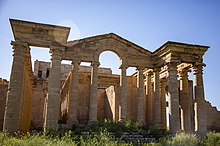
 The ruins of Hatra in 2019 | |
| Alternative name | al-Ḥaḍr |
|---|---|
| Location | Hatra District, Nineveh Governorate, Iraq |
| Region | Mesopotamia |
| Coordinates | 35°35′17″N 42°43′6″E / 35.58806°N 42.71833°E |
| Type | Settlement, temple |
| Area | 300 ha (740 acres) |
| History | |
| Founded | 3rd or 2nd century BC |
| Abandoned | 241 AD |
| Cultures | Arab,[citation needed] Mesopotamian, Assyrian, Parthian |
| Satellite of | Parthian Empire |
| Site notes | |
| Condition | Ruins |
| Public access | Accessible |
| Official name | Hatra |
| Type | Cultural |
| Criteria | ii, iii, iv, vi |
| Designated | 1985 (9th session) |
| Reference no. | 277 |
| Region | Arab States |
Hatra (/ˈhæ.trə/; Arabic: الحضر (Arabic pronunciation: [ˈħadˀ.ra]); Syriac: ܚܛܪܐ) was an ancient city in Upper Mesopotamia located in present-day eastern Nineveh Governorate in northern Iraq. The ruins of the city lie 290 km (180 mi) northwest of Baghdad and 110 km (68 mi) southwest of Mosul. It is considered the richest archaeological site from the Parthian Empire known to date.[1]
Hatra was a strongly fortified caravan city and capital of the small Arab Kingdom of Hatra, located between the Roman and Parthian/Sasanian Empires. Hatra flourished in the 2nd century, and was destroyed and deserted in the 3rd century. Its ruins were discovered in the 19th century.[2]
- ^ Dirven, L. (2013). Hatra: Politics, Culture and Religion Between Parthia and Rome. Franz Steiner Verlag. ISBN 978-3-515-10507-1. Retrieved 2023-09-29.
- ^ Cite error: The named reference
Schmittwas invoked but never defined (see the help page).


