Back Haut-Rhin Afrikaans Département Haut-Rhin ALS Alto Rin AN الراين الأعلى (إقليم فرنسي) Arabic Altu Rin AST Yuxarı Reyn Azerbaijani او-رن AZB Верхні Рэйн Byelorussian Верхні Райн (дэпартамэнт) BE-X-OLD О Рен Bulgarian
You can help expand this article with text translated from the corresponding article in French. (November 2009) Click [show] for important translation instructions.
|
Haut-Rhin
's Owerlànd, Owerelsàss | |
|---|---|
 Prefecture building of the Haut-Rhin department, in Colmar | |
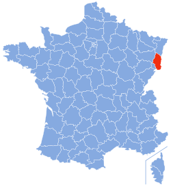
 Location of Haut-Rhin in France | |
| Coordinates: 47°57′51″N 7°19′11″E / 47.96417°N 7.31972°E | |
| Country | France |
| Region | Grand Est |
| Prefecture | Colmar |
| Subprefectures | Altkirch Mulhouse Thann |
| Government | |
| • Prefect | Louis Laugier[1] |
| Area | |
• Total | 3,525 km2 (1,361 sq mi) |
| Population (2021)[2] | |
• Total | 767,083 |
| • Rank | 29th |
| • Density | 220/km2 (560/sq mi) |
| Time zone | UTC+1 (CET) |
| • Summer (DST) | UTC+2 (CEST) |
| Department number | 68 |
| Arrondissements | 4 |
| Cantons | 17 |
| Communes | 366 |
| ^1 French Land Register data, which exclude estuaries, and lakes, ponds, and glaciers larger than 1 km2 | |
| Part of a series on |
| Alsace |
|---|
|
|
Haut-Rhin (French pronunciation: [oʁɛ̃] )[3] is a département in the Grand Est region, France, bordering both Germany and Switzerland. It is named after the river Rhine. Its name means Upper Rhine. Haut-Rhin is the smaller and less populated of the two departments of the former administrative Alsace region, the other being the Bas-Rhin (Lower Rhine). Especially after the 1871 cession of the southern territory known since 1922 as Territoire de Belfort, although it is still rather densely populated compared to the rest of metropolitan France. It had a population of 767,083 in 2021.[4]
On 1 January 2021, the départemental collectivities of Bas-Rhin and Haut-Rhin were merged into the European Collectivity of Alsace.
- ^ Décret du 29 juillet 2020 portant nomination du préfet du Haut-Rhin, Légifrance
- ^ "Téléchargement du fichier d'ensemble des populations légales en 2021" (in French). The National Institute of Statistics and Economic Studies. 28 December 2023.
- ^ lit. 'Upper Rhine'; Alsatian: Owerelsàss or ‘s Iwerlànd;Office pour la Langue et la Culture d’Alsace. "Wàs brücht m'r im Elsàss ? Petit lexique français-alsacien" (PDF). oclalsace.org (in French). Archived (PDF) from the original on 2022-10-09. Retrieved 10 December 2013. German: Oberelsass, lit. 'Upper Alsace'
- ^ "Populations légales en vigueur à compter du 1er janvier 2024: 68 Haut-Rhin" (PDF). INSEE. Retrieved 16 January 2024.

