Back Haute-Loire Afrikaans Département Haute-Loire ALS Alta Loira AN لوار العليا (إقليم فرنسي) Arabic Altu Loira AST Yuxarı Luara Azerbaijani Верхняя Луара Byelorussian Верхняя Люара BE-X-OLD От Лоар Bulgarian Liger-Uhel Breton
Haute-Loire
Naut Léger (Occitan) | |
|---|---|
|
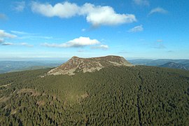
From top to bottom, left to right: Mont Mézenc, prefecture building in Le Puy-en-Velay, St Julien Basilica in Brioude and view of Boën-sur-Lignon | |
 Location of Haute-Loire in France | |
| Coordinates: 45°0′N 4°0′E / 45.000°N 4.000°E | |
| Country | France |
| Region | Auvergne-Rhône-Alpes |
| Prefecture | Le Puy-en-Velay |
| Subprefectures | Brioude Yssingeaux |
| Government | |
| • President of the Departmental Council | Marie-Agnès Petit[1] (LR) |
| Area | |
| • Total | 4,977 km2 (1,922 sq mi) |
| Population (2021)[2] | |
| • Total | 227,284 |
| • Rank | 87th |
| • Density | 46/km2 (120/sq mi) |
| Time zone | UTC+1 (CET) |
| • Summer (DST) | UTC+2 (CEST) |
| Department number | 43 |
| Arrondissements | 3 |
| Cantons | 19 |
| Communes | 257 |
| ^1 French Land Register data, which exclude estuaries and lakes, ponds and glaciers larger than 1 km2 | |
Haute-Loire (French pronunciation: [ot lwaʁ] ; Occitan: Naut Léger or Naut Leir; English: Upper Loire) is a landlocked department in the Auvergne-Rhône-Alpes region of south-central France. Named after the Loire River, it is surrounded by the departments of Loire, Ardèche, Lozère, Cantal and Puy-de-Dôme. In 2019, it had a population of 227,570;[3] its inhabitants are called Altiligériens in French (English : Altiligerians).
The department, which has its prefecture in Le Puy-en-Velay, covers the upper reaches of the Loire and consists of the Loire Valley and the surrounding mountains in the Massif Central. It is one of the original 83 departments of France created in 1790 during the French Revolution. Parts of the department are included in the Livradois-Forez Regional Natural Park.
- ^ "Répertoire national des élus: les conseillers départementaux". data.gouv.fr, Plateforme ouverte des données publiques françaises (in French). 4 May 2022.
- ^ "Téléchargement du fichier d'ensemble des populations légales en 2021" (in French). The National Institute of Statistics and Economic Studies. 28 December 2023.
- ^ Populations légales 2019: 43 Haute-Loire, INSEE


