Back ولاية هرات Arabic Herat AST Herat vilayəti Azerbaijani هرات ویلایت AZB Герат (правінцыя) Byelorussian Герат (правінцыя) BE-X-OLD Херат (провинция) Bulgarian হেরাত প্রদেশ Bengali/Bangla Província d'Herat Catalan Herāt (lalawigan) CEB
This article needs to be updated. (July 2023) |
Herat
هرات | |
|---|---|
. | |
 Map of Afghanistan with Herat highlighted | |
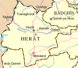
 Detail map of Herat province | |
| Coordinates (Capital): 34°00′N 62°00′E / 34.0°N 62.0°E | |
| Country | |
| Capital | Herat |
| Government | |
| • Governor | Noor Mohammad Islamjar[1] |
| • Deputy Governor | Abdul Qayyum Rohani |
| Area | |
| • Total | 55,868 km2 (21,571 sq mi) |
| Population (2021)[2] | |
| • Total | 3,780,000 |
| • Density | 68/km2 (180/sq mi) |
| Time zone | UTC+4:30 (Afghanistan Time) |
| Postal code | 30xx |
| ISO 3166 code | AF-HER |
| Main languages | Pashto, Dari |
Herat (Pashto/Dari: هرات) is one of the thirty-four provinces of Afghanistan, located in the western part of the country. Together with Badghis, Farah, and Ghor provinces, it makes up the north-western region of Afghanistan. Its primary city and administrative capital is Herat City. The province of Herat is divided into about 17 districts and contains over 2,000 villages. It has a population of about 3,780,000, making it the second most populated province in Afghanistan behind Kabul Province.[2] The population is multi-ethnic but largely Persian-speaking. Herat dates back to the Avestan times and was traditionally known for its wine. The city has a number of historic sites, including the Herat Citadel and the Musalla Complex. During the Middle Ages Herat became one of the important cities of Khorasan, as it was known as the Pearl of Khorasan.[3]
The province of Herat shares a border with Iran in the west and Turkmenistan in the north, making it an important trading region. The Trans-Afghanistan Pipeline (TAPI) is expected to pass through Herat from Turkmenistan to Pakistan and India in the south. The province has two airports, one is the Herat International Airport in the capital of Herat and the other is at the Shindand Air Base, which is one of the largest military bases in Afghanistan. The Salma Dam which is fed by the Hari River is also located in this province.
- ^ "د هرات ولايت نوي والي او مرستیال والي معرفي او دندې یې پيل کړې – الاماره پښتو".
- ^ a b "Estimated Population of Afghanistan 2021–22" (PDF). nsia.gov.af. National Statistic and Information Authority (NSIA). April 2021. Archived from the original (PDF) on June 24, 2021. Retrieved June 29, 2021.
- ^ The Best Attractions In Herat Province www.destimap.com, accessed 8 October 2023


