This article is written like a personal reflection, personal essay, or argumentative essay that states a Wikipedia editor's personal feelings or presents an original argument about a topic. (September 2019) |
This article includes a list of references, related reading, or external links, but its sources remain unclear because it lacks inline citations. (July 2022) |
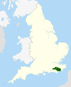
The High Weald National Landscape is in south-east England. Covering an area of 1,450 square kilometres (560 sq mi), it takes up parts of Kent, Surrey, East Sussex, and West Sussex.[1] It is the fourth largest Area of Outstanding Natural Beauty (AONB) in England and Wales. It has an attractive landscape with a mosaic of small farms and woodlands, historic parks, sunken lanes and ridge-top villages.
The area consists of 99 parishes and a total population of approximately 120,000 persons.[2] The main communities are Royal Tunbridge Wells, Crowborough, Hastings and Haywards Heath.[3]
- ^ "Where is the High Weald?". High Weald AONB. Retrieved 30 August 2022.
- ^ "High Weald Villages and Towns". Landscapes for Life, High Weald. Retrieved 30 August 2022.
- ^ "High Weald AONB". Essential Travel Guide. Retrieved 30 August 2022.


