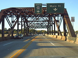
Hill to Hill Bridge | |
|---|---|
 Hill to Hill Bridge heading northbound in October 2005 | |
| Coordinates | 40°36′56″N 75°23′05″W / 40.6155°N 75.3846°W |
| Carries | 4 lanes of |
| Crosses | Lehigh River |
| Locale | Bethlehem, Pennsylvania, U.S. |
| Official name | Hill to Hill Bridge |
| Other name(s) | Route 378 Bridge |
| Characteristics | |
| Design | concrete arch truss bridge |
| History | |
| Opened | 1924 |
| Statistics | |
| Toll | Free |
| Location | |
 | |
The Hill to Hill Bridge is a road crossing of the Lehigh River and linking the south and north sides of Bethlehem, Pennsylvania in the Lehigh Valley region of eastern Pennsylvania.
Completed in 1924, Hill to Hill Bridge carries Pennsylvania Route 378 from Wyandotte Street on Bethlehem's south side to a series of ramps and viaducts on the north side. It replaced a two-lane covered bridge and eliminated several grade crossings of three railroads on the two banks of the Lehigh River. The Hill to Hill Bridge is located in the Central Bethlehem Historic District and was added to the National Register of Historic Places in 1972 with a boundary increase to the designation added in 1988.[1]
