Back هيلبورن (نيويورك) Arabic Hillburn Catalan Hillburn CEB Hillburn, Efrog Newydd Welsh Hillburn Spanish Hillburn (New York) Basque Hillburn French Hillburn, New York HT Hillburn Italian Hillburn (New York) LLD
Hillburn, New York | |
|---|---|
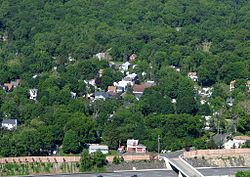
 View of Hillburn from Nordkop Mountain, looking west; NY State Thruway in foreground | |
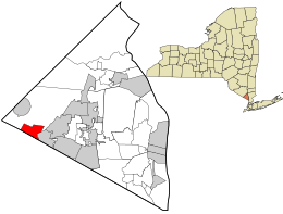
 Location in Rockland County and the state of New York. | |
| Coordinates: 41°7′29″N 74°9′57″W / 41.12472°N 74.16583°W | |
| Country | United States |
| State | New York |
| County | Rockland |
| Incorporated | 1893 |
| Government | |
| • Mayor | Joseph P. Tursi |
| • Trustees | Bonnie R. O'Blenis, and Bernadette Tarantino |
| Area | |
• Total | 2.25 sq mi (5.83 km2) |
| • Land | 2.23 sq mi (5.78 km2) |
| • Water | 0.02 sq mi (0.05 km2) |
| Elevation | 305 ft (93 m) |
| Population | |
• Total | 930 |
| • Density | 416.29/sq mi (160.77/km2) |
| Time zone | UTC-5 (EST) |
| • Summer (DST) | UTC-4 (EDT) |
| ZIP code | 10931 |
| Area code | 845 |
| FIPS code | 36-34660 |
| GNIS feature ID | 0952811 |
| Website | http://www.hillburn.org/ |
Hillburn, originally called "Woodburn" and incorporated in 1893, is a village in the town of Ramapo, Rockland County, New York, United States. It is located north of Suffern, east of Orange County, south of Viola, and west of Montebello. It is considered to be one of the more rural communities in Rockland County. The population was 930 at the 2020 census.[2]
- ^ "ArcGIS REST Services Directory". United States Census Bureau. Retrieved September 20, 2022.
- ^ a b "2020 Census Redistricting Data: Hillburn village; New York". data.census.gov. U.S. Census Bureau. Retrieved June 9, 2023.
