Back Hongcongieg ANG جزيرة هونغ كونغ Arabic جزيره هونج كونج ARZ Islla de Ḥong Kong AST Ганконг (востраў) Byelorussian Хонконг (остров) Bulgarian হংকং দ্বীপ Bengali/Bangla Enez Hong Kong Breton Illa de Hong Kong Catalan Hong Kong Island CEB
香港島 | |
|---|---|
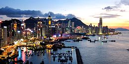
 Dusk view of Hong Kong Island as viewed from North Point, August 2011 | |
 Location (in red) within Hong Kong | |
| Geography | |
| Coordinates | 22°15′52″N 114°11′14″E / 22.26444°N 114.18722°E |
| Area | 78.59 km2 (30.34 sq mi) |
| Highest elevation | 552 m (1811 ft) |
| Highest point | Victoria Peak |
| Demographics | |
| Population | 1,188,500 (2023) |
| Pop. density | 16,390/km2 (42450/sq mi) |
| Ethnic groups |
|
| Hong Kong Island | |||||||||||||||||||||||||||||||||||
|---|---|---|---|---|---|---|---|---|---|---|---|---|---|---|---|---|---|---|---|---|---|---|---|---|---|---|---|---|---|---|---|---|---|---|---|
| Traditional Chinese | 香港島 | ||||||||||||||||||||||||||||||||||
| Simplified Chinese | 香港岛 | ||||||||||||||||||||||||||||||||||
| Cantonese Yale | Hēunggóng dóu | ||||||||||||||||||||||||||||||||||
| Jyutping | Hoeng1 gong2 dou2 | ||||||||||||||||||||||||||||||||||
| |||||||||||||||||||||||||||||||||||
Hong Kong Island (Chinese: 香港島; Jyutping: Hoeng1 gong2 dou2; Cantonese Yale: Hēunggóng dóu) is an island in the southern part of Hong Kong. The island, known originally and on road signs simply as "Hong Kong", had a population of 1,289,500 and a population density of 16,390 per square kilometre (42,400/sq mi),[2] as of 2023[update]. It is the second largest island in Hong Kong, with the largest being Lantau Island. Hong Kong Island forms one of the three areas of Hong Kong, with the other two being Kowloon and the New Territories.[3]
In 1842, following the Qing dynasty's defeat at the First Opium War (1839–1842), Hong Kong Island was formally ceded in perpetuity to the United Kingdom under the Treaty of Nanking. The City of Victoria was then established on the island by British forces in honour of Queen Victoria. At the time, the island had a population of about 3,000 inhabitants scattered in a dozen fishing villages.
The northern-east part of the island, being known as the Central area is the historical, political, and economic centre of Hong Kong, with many government buildings being in the area, namely the Government House, Central Government Complex, Legislative Council Complex, Hong Kong Court of Final Appeal and High Court of Hong Kong. Many financial institutes and banks such as the Hong Kong Stock Exchange, Hong Kong Monetary Authority, HSBC and Bank of China are also based in the area.
The northern coast of the island forms the southern shore of the Victoria Harbour, which is largely responsible for the development of Hong Kong due to its deep waters favoured by large trade ships. The island is home to many famous tourists sights, such as "The Peak", Ocean Park, Former Central Police Station Compound, Murray House, and many other historical sites and various large shopping centres. The mountain ranges across the island are also famous for hiking.
The northern part of Hong Kong Island, together with Kowloon and Tsuen Wan New Town, forms the core urban area of Hong Kong. Their combined area is approximately 88.3 square kilometres (34.1 square miles) and their combined population is approximately 3,156,500, reflecting a population density of 35,700 people/km2 (92,000 people/sq mi).
The island is often referred to locally as "Hong Kong side" or "Island side". The suffix "-side" is also applied to other locations in Hong Kong (e.g. China-side and Kowloon Walled City-side), the sole remnant of which being the "Kowloon side" when referring to the two sides of the Victoria Harbour.[4][page needed][better source needed]
- ^ "District Profiles". 2021 Population Census.
- ^ Census and Statistics Department (2008), Population and Vital Events (PDF), archived from the original (PDF) on 24 August 2009, retrieved 31 August 2009
- ^ "Areas of Districts" (PDF). Rating and Valuation Department.
- ^ Booth, Martin (2005), Gweilo: memories of a Hong Kong childhood, London: Bantam, ISBN 978-0-553-81672-3