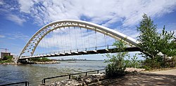
Humber Bay Arch Bridge
| |
|---|---|
 The Humber Bay Arch Bridge seen from the west bank of the Humber River | |
| Coordinates | 43°37′55″N 79°28′16″W / 43.631896°N 79.471246°W |
| Carries | pedestrian & bicycle traffic |
| Crosses | Humber River |
| Locale | Toronto |
| Maintained by | Toronto Transportation Services[1] |
| Characteristics | |
| Design | Double-ribbed arch bridge[1] |
| Material | Steel tubes[2] |
| Total length | 130 metres (430 ft)[2] |
| Height | 21.3 metres (70 ft) above grade[1] |
| Longest span | 100 metres (330 ft)[2] |
| No. of spans | 1 |
| Piers in water | 0 |
| History | |
| Designer | Montgomery and Sisam Architects[1] |
| Construction end | 1994[1] |
| Location | |
 | |
The Humber Bay Arch Bridge (also known as the Humber River Arch Bridge, the Humber River Pedestrian Bridge, or the Gateway Bridge) is a pedestrian and bicycle through arch bridge south of Lake Shore Boulevard West in Toronto, Ontario, Canada. Completed in the mid-1990s, the bridge is part of the Martin Goodman Trail and is 139 metres (456 ft) in length, with a clear span of 100 metres (330 ft) over the mouth of the Humber River to protect the environmental integrity of the waterway.
- ^ a b c d e American Society of Civil Engineers (2007). Bridges 2008. ASCE. July bridge. ISBN 978-0-7844-0945-9.
- ^ a b c Humber River Pedestrian-Bicycle Bridge at Structurae
