Back الجزر الأيونية Arabic Islles Xóniques AST İon adaları Azerbaijani Іанічныя астравы Byelorussian Іянічныя астравы BE-X-OLD Йонийски острови Bulgarian Inizi Ionian Breton Illes Jòniques Catalan Ионийн гӀайренаш CE Ionian Islands (kapuloan) CEB
Ionian Islands
Ιόνιοι Νήσοι Iónioi Nísoi | |
|---|---|
 Cape Drastis (Corfu) | |
 | |
| Coordinates: 37°48′N 20°42′E / 37.800°N 20.700°E | |
| Country | Greece |
| Cession | 1864 |
| Capital | Corfu |
| Islands | |
| Area | |
• Total | 2,306.94 km2 (890.71 sq mi) |
| Population (2011)[1] | |
• Total | 207,855 |
| • Density | 90/km2 (230/sq mi) |
| Demonym(s) | Heptanesian, Septinsular |
| Time zone | UTC+2 (EET) |
| • Summer (DST) | UTC+3 (EEST) |
| ISO 3166 code | GR-F |
| Website | www |
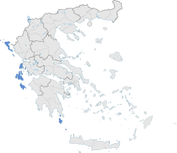
The Ionian Islands (Modern Greek: Ιόνια νησιά, Ionia nisia; Ancient Greek, Katharevousa: Ἰόνιαι Νῆσοι, Ioniai Nēsoi) are a group of islands in the Ionian Sea, west of mainland Greece. They are traditionally called the Heptanese ("Seven Islands"; Ἑπτάνησα, Heptanēsa or Ἑπτάνησος, Heptanēsos; Italian: Eptaneso), but the group includes many smaller islands in addition to the seven principal ones.
As a distinct historic region, they date to the centuries-long Venetian rule, which preserved them from the Muslim conquests of the Ottoman Empire, and created a distinct cultural identity with many Italian influences. The Ionian Islands became part of the modern Greek state in 1864. Administratively today, they belong to the Ionian Islands Region except for Kythera, which belongs to the Attica Region.
- ^ "Demographic and social characteristics of the Resident Population of Greece according to the 2011 Population - Housing Census revision of 20/3/2014" (PDF). Hellenic Statistical Authority. 12 September 2014. Archived from the original (PDF) on 8 September 2015.