Back Итакуатиара CE Itacoatiara (munisipyo) CEB Itacoatiara German Itacoatiara (Amazonio) Esperanto Itacoatiara Spanish Itacoatiara Basque ایتاکواتیرا (آمازوناس) Persian Itacoatiara French इटाकोटियारा, आमेज़ोनास Hindi Իտակուատիարա Armenian
Itacoatiara | |
|---|---|
| Município de Itacoatiara Municipality of Itacoatiara | |
 Itacoatiara, Amazonas, Brazil | |
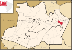
 Location in the state of Amazonas | |
| Coordinates: 03°08′34″S 58°26′38″W / 3.14278°S 58.44389°W | |
| Country | |
| Region | North |
| State | |
| Founded | April 24, 1874 |
| Government | |
| • Mayor | Antônio Peixoto de Oliveira (Workers Party) |
| Area | |
| • Total | 8,891.993 km2 (3,433.218 sq mi) |
| Elevation | 40 m (130 ft) |
| Population (2020) | |
| • Total | 102,701 |
| • Metro density | 10.016/km2 (25.94/sq mi) |
| Time zone | UTC−4 (AMT) |
| Area code | +55 (92) |
| Climate | Af |
Itacoatiara is a municipality in the central eastern portion of state of Amazonas, inland northern Brazil.
Its population was 102,701 (2020)[1] and its area is 8,600 km2.[2]
The town is known as "City of painted stone" - which is its name translated from Tupi. Itacoatiara has an important port, which is responsible for a considerable amount of cargo transportation in Amazonas.
Its Catedral Prelatícia Nossa Senhora do Rosário, dedicated to Our Lady of the Rosary, is the episcopal see of the pre-diocesan Roman Catholic Territorial Prelature of Itacoatiara.
- ^ IBGE 2020
- ^ Brazilian Institute of Geography and Statistics (IBGE) - "Archived copy". Archived from the original on 2007-01-09. Retrieved 2014-08-03.
{{cite web}}: CS1 maint: archived copy as title (link)


