Back جنين (مدينة) Arabic جنين (مدينه) ARZ Cenin Azerbaijani Дженин Bulgarian Jenin Catalan Дженин CE Janīn (lungsod) CEB Dženín Czech Jenin Welsh Jenin Danish
Jenin | |
|---|---|
| Arabic transcription(s) | |
| • Arabic | جنين |
| • Latin | Jinin (official) Janin (unofficial) |
| Hebrew transcription(s) | |
| • Hebrew | ג׳נין |
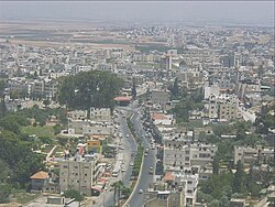
 Jenin skyline | |
Location of Jenin within Palestine | |
| Coordinates: 32°27′40″N 35°18′00″E / 32.46111°N 35.30000°E | |
| Palestine grid | 178/207 |
| State | |
| Governorate | Jenin |
| Government | |
| • Type | City |
| Area | |
• Total | 37,342 dunams (37.3 km2 or 14.4 sq mi) |
| Population (2017)[1] | |
• Total | 49,908 |
| • Density | 1,300/km2 (3,500/sq mi) |
| (plus 10,371 in Jenin refugee camp) | |
Jenin (/ʒɪˈniːn/ zhin-EEN; Arabic: جنين, romanized: Jinīn, locally pronounced [ʒɪˈniːn] ) is a city in the State of Palestine in the Israeli-occupied West Bank. The city serves as the administrative center of the Jenin Governorate of Palestine and is a major center for the surrounding towns.[2] Jenin came under Israeli occupation in 1967 and was put under the administration of the Palestinian National Authority as Area A of the West Bank in 1993.
In 2017, Jenin had a population of approximately 50,000 people, whilst the Jenin refugee camp had a population of about 10,000, housing Palestinians who fled or were expelled from their homes during the 1948 Palestine War.[1][3] The camp has since become a stronghold of Palestinian militants against British colonialism and Israeli occupation, being the location of several incidents relating to the Israeli–Palestinian conflict.
- ^ a b Preliminary Results of the Population, Housing and Establishments Census, 2017 (PDF). Palestinian Central Bureau of Statistics (PCBS) (Report). State of Palestine. February 2018. pp. 64–82. Retrieved 2023-10-24.
- ^ "Jenin City". Welcome To Palestine. Retrieved 2022-06-18.
- ^ 2007 Locality Population Statistics Archived 2010-12-10 at the Wayback Machine. Palestinian Central Bureau of Statistics
