Back جبال جينجقانج ARZ Jinggangbjergene Danish Montes Jinggang Spanish Jinggang mendiak Basque Jinggangshan Finnish Massif du Jinggang French 井岡山 GAN Pegunungan Jinggang ID Monti Jinggang Italian 井岡山 Japanese
This article needs additional citations for verification. (December 2007) |
| Jinggang Mountains | |
|---|---|
| 井冈山 | |
 | |
| Highest point | |
| Elevation | 2,120 m (6,960 ft) |
| Coordinates | 26°36′13″N 114°11′45″E / 26.60361°N 114.19583°E |
| Geography | |
| Location | Hunan and Jiangxi, China |
| Parent range | Luoxiao Mountains |
| Jinggang Mountains | |||||||||
|---|---|---|---|---|---|---|---|---|---|
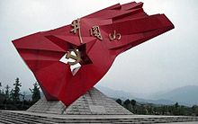
 Red Army commemorative monument atop a summit of the Jinggang Range | |||||||||
| Simplified Chinese | 井冈山 | ||||||||
| Traditional Chinese | 井岡山 | ||||||||
| Postal | Chingkang Mountains | ||||||||
| Literal meaning | Well Ridge Mountains | ||||||||
| |||||||||
| Jinggang | |||||||||
| Simplified Chinese | 井冈 | ||||||||
| Traditional Chinese | 井岡 | ||||||||
| Postal | Chingkang | ||||||||
| Literal meaning | Well Ridge | ||||||||
| |||||||||
The Jinggang Mountains, historically rendered as Chingkang Mountains are a mountain range of the Luoxiao Mountains System, in the border region of Jiangxi and Hunan Provinces.
The range lies at the junction of four counties - Ninggang, Yongxing, Suichuan and Lingxiang. The mountains cover some 670 km2 (260 sq mi), with an average elevation of 381.5 metres (1,252 ft) above sea level. The highest point is 2,120 m (6,960 ft) above sea level.
The range's massif consists of a number of thickly forested parallel ridges. On the heights there is not much farmland with most settlements at the base of the mountains. The main settlement is at Ciping, which is surrounded by five villages whose literal meanings are Big Well, Little Well, Middle Well, Lower Well, and Upper Well. Henceforth came the name of the mountain, literally means "Well Ridge Mountains".
Jinggang Mountains have rich reserves of porcelain clay and rare earth ore, which are two major dominant minerals. Jinggang Mountains are also known as “the cradle of the Chinese revolution”.[1]
- ^ Liu, Zengwen; Duan, Erjun; Gao, Wenjun (2009). "Influences of leaf litter replacement on soil biochemical characteristics of main planted forests in Qinling Mountains of China". Frontiers of Agriculture in China. 3 (3): 346–352. doi:10.1007/s11703-009-0049-3. S2CID 85210595.

