Back Daerah Johor Baharu CEB Distrito de Johor Bahru Spanish منطقه جوهور بهرو Persian Distrik Johor Bahru ID Distretto di Johor Bahru Italian Daerah Johor Bahru Malay Johor Bahru (district) Dutch Johor Bahru District SIMPLE ஜொகூர் பாரு மாவட்டம் Tamil อำเภอโจโฮร์บะฮ์รู Thai
Johor Bahru District | |
|---|---|
| Daerah Johor Bahru | |
| Other transcription(s) | |
| • Jawi | جوهر بهارو |
| • Chinese | 新山县 |
| • Tamil | ஜொகூர் பாரு |
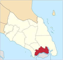
 Location of Johor Bahru District in Johor | |
 | |
Location of Johor Bahru District in Malaysia | |
| Coordinates: 1°32′N 103°43′E / 1.533°N 103.717°E | |
| Country | |
| State | |
| Seat | Johor Bahru |
| Local area government(s) | Iskandar Puteri City Council (Johor Bahru West and North) Johor Bahru City Council (Johor Bahru City Centre) Pasir Gudang City Council (Johor Bahru East) |
| Government | |
| • District officer | Haji Abdul Rahman bin Salleh |
| Area | |
• Total | 1,063.97 km2 (410.80 sq mi) |
| Population (2023) | |
• Total | 1,758,500 |
| • Density | 1,700/km2 (4,300/sq mi) |
| Time zone | UTC+8 (MST) |
| • Summer (DST) | UTC+8 (Not observed) |
| Postcode | 79xxx - 81xxx |
| Calling code | +6-07-2, +6-07-3, +6-07-5 |
| Vehicle registration plates | J |

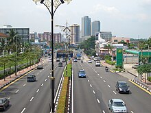
The Johor Bahru District is a district located in the southern part of Johor, Malaysia. The heavily suburban/suburbanizing district covers an area of 1,063.97 km2 (410.80 sq mi) and has a population of 1.71 million. The district capital is Johor Bahru City and the administrative capital is Iskandar Puteri City. The district borders Pontian District on the west, Kota Tinggi District on the east, Kulai District on the north and Straits of Johor to the south. The urban centres are divided into the cities of Johor Bahru, Iskandar Puteri and Pasir Gudang.
It is host to many thriving townships such as the Tebrau area, which hosts several shopping malls including a ÆON Mall, Tesco, Toppen Shopping Centre and an IKEA outlet.
The district office is located in Johor Bahru.
- ^ "Profil Daerah". Archived from the original on 4 May 2017. Retrieved 27 July 2016.


