Back Kamtsjatka-skiereiland Afrikaans Kamtschatka ALS شبه جزيرة كامشاتكا Arabic Península de Kamchatka AST Kamçatka Azerbaijani Камчатка Bashkir Камчатка Byelorussian Камчатка (паўвостраў) BE-X-OLD Камчатка Bulgarian কামচাতকা উপদ্বীপ Bengali/Bangla
полуостров Камчатка | |
|---|---|
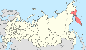
 Kamchatka Peninsula in the far east of Russia. The highlighted area is the Kamchatka Krai which includes some of the mainland to the north. | |
 | |
| Geography | |
| Location | Far East |
| Coordinates | 57°N 160°E / 57°N 160°E |
| Adjacent to | Sea of Okhotsk Pacific Ocean |
| Area | 270,000 km2 (100,000 sq mi) |
| Length | 1,250 km (777 mi) |
| Highest elevation | 4,750 m (15580 ft) |
| Highest point | Klyuchevskaya Sopka |
| Administration | |
| Federal subject | Kamchatka Krai |
| Capital city | Petropavlovsk-Kamchatsky |
| Demographics | |
| Population | 289,033 (2023 estimate)[1] |
| Pop. density | 0.62/km2 (1.61/sq mi) |
The Kamchatka Peninsula[a] (Russian: полуостров Камчатка, romanized: poluostrov Kamchatka, pronounced [pəlʊˈostrəf kɐmˈt͡ɕætkə]) is a 1,250-kilometre-long (777 mi) peninsula in the Russian Far East, with an area of about 270,000 km2 (100,000 sq mi).[3] The Pacific Ocean and the Sea of Okhotsk make up the peninsula's eastern and western coastlines, respectively.[2] Immediately offshore along the Pacific coast of the peninsula runs the 9,600-metre-deep (31,496 ft) Kuril–Kamchatka Trench.
The Kamchatka Peninsula, the Commander Islands, and Karaginsky Island constitute Kamchatka Krai of the Russian Federation. The majority of the 322,079 inhabitants are ethnic Russians, with about 13,000 being Koryaks (2014).[4] More than half of the population lives in Petropavlovsk-Kamchatsky (179,526 in 2010) and nearby Yelizovo (38,980). The Kamchatka peninsula contains the volcanoes of Kamchatka, a UNESCO World Heritage Site.
- ^ "Предварительная оценка численности постоянного населения на 1 января 2023 г." [Preliminary estimate of the resident population as of January 1, 2023]. Federal State Statistics Service. Retrieved 21 February 2023.
- ^ a b "Kamchatka Peninsula". Encyclopædia Britannica. Retrieved 2008-02-20.
- ^ Быкасов В. Е. Ошибка в географии(in Russian) // Известия Всесоюзного Географического Общества. — 1991. — № 6. (in Russian)
- ^ "Kamchatka Peninsula". Government of Kamchatskiy Kray. Archived from the original on 13 October 2010. Retrieved 17 October 2014.
Cite error: There are <ref group=lower-alpha> tags or {{efn}} templates on this page, but the references will not show without a {{reflist|group=lower-alpha}} template or {{notelist}} template (see the help page).