Back ولاية كايانغيل Arabic State of Kayangel CEB Kayangel Danish Kayangel (Palau) German Estado de Kayangel Spanish کایانگل Persian Kayangel Finnish Kayangel French Kayangel ID Kayangel Italian
Kayangel | |
|---|---|
 | |
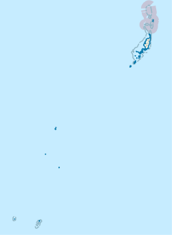
 Location of Kayangel in Palau | |
| Country | |
| Capital | Orukei |
| Government | |
| • Body | Kayangel State Legislature |
| • Governor | Richard Ngiraked[1] |
| Area | |
• Total | 1.4 km2 (0.5 sq mi) |
| Population (2015 Census) | |
• Total | 54 |
| • Density | 39/km2 (100/sq mi) |
| • Official languages | Palauan English |
| ISO 3166 code | PW-100 |

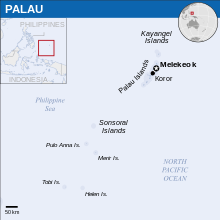
Kayangel[2][3] (Ngcheangel) is the northernmost state of Palau[4][5] 86 km (53 mi) north of Koror. The land area is about 1.4 km2 (0.54 sq mi). The population is 54 (2015 census). There is one hamlet in the state - Orukei, which is also its capital. In 2020, Richard Ngiraked was elected governor of the state.[6]
- ^ Reklai, Leilani (18 June 2024). "Two State Elections See Lack of Challengers". Island Times.
- ^ Olsudong, Rita (2006). Final Inventory of Historic Properties in Kayangel States, Republic of Palau. Bureau of Arts and Culture, Palau Historic Preservation Office, Ministry of Community and Cultural Affairs.
- ^ Trust Territory of the Pacific Islands. Bureau of International Organization Affairs, Office of United Nations Political Affairs.
- ^ Holyoak, Lorne (2005). Ethnographic and Oral History Survey of Kayangel State, Republic of Palau. Palau Bureau of Arts and Culture and Historic Preservation Office, Ministry of Community and Regional Affairs.
- ^ Federal Information Processing Standards Publication. U.S. Government Printing Office. 1994.
- ^ "KAYANGEL GOVERNOR RETURNS $100K FOR SEABED LEASE – Tia Belau Newspaper". 2021-10-04. Retrieved 2024-04-29.
