Back Kentucky Bend Czech Kentucky Bend German Kentucky Bend Spanish 켄터키 벤드 Korean Kentucky Bend Dutch Kentucky Bend Portuguese
Kentucky Bend | |
|---|---|
Peninsula | |
 | |
| Nickname(s): New Madrid Bend, Madrid Bend, Bessie Bend, Bubbleland | |
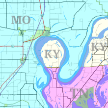
 Kentucky Bend (center) and surrounding area | |
| Coordinates: 36°32′N 89°31′W / 36.53°N 89.51°W | |
| County | Fulton |
| State | Kentucky |
| Country | United States |
| Population (2020) | |
| • Total | 9 |
| ZIP code | 38079 |

The Kentucky Bend, variously called the New Madrid Bend, Madrid Bend, Bessie Bend, or Bubbleland,[1][2] is an exclave of Fulton County, Kentucky that is encircled by the states of Tennessee and Missouri. The exclave is a portion of a peninsula defined by an oxbow loop meander of the Mississippi River, and its inclusion in the state of Kentucky stems from uncertainties of the course of the Mississippi River when the boundary between Tennessee and Kentucky was established.
As of the 2020 census, the population of the Kentucky Bend Census County Division was nine people.[3] The mailing address of the area is Tiptonville, Tennessee. New Madrid, Missouri is directly across the river to the north, but it lacks connection to the bend by road or ferry. The closest crossings of the Mississippi River are the Dorena–Hickman Ferry and the Caruthersville Bridge located in nearby Dyer County.
- ^ Suhr, Jim (September 8, 2002). "Kentuckians Hold True to Their Quiet Bend". LA Times. Retrieved September 28, 2019.
- ^ Jennings, Ken (August 5, 2013). "Ken Jennings Takes You on a Trip to Bubbleland, Where Sadly You Will Find No Bubbles". Conde Nast Traveler. Retrieved September 28, 2019.
- ^ "Kentucky Bend CCD". The United States Census Bureau.