Back كي ويست Arabic كى ويست ARZ Ki-Vest Azerbaijani کی وست، فلوریدا AZB Кі-Уэст Byelorussian কি ওয়েস্ট Bengali/Bangla Key West (Florida) Breton Key West Catalan Ки-Вест CE Key West (kapital sa kondado) CEB
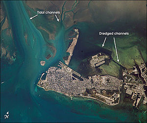
 An October 2002 NASA image of Key West from space | |
 | |
| Geography | |
|---|---|
| Coordinates | 24°33′55″N 81°46′33″W / 24.565176°N 81.775794°W[1] |
| Archipelago | Florida Keys |
| Area | 4.2 sq mi (11 km2) |
| Length | 4 mi (6 km) |
| Width | 1 mi (2 km) |
| Highest elevation | 18 ft (5.5 m) |
| Highest point | Solares Hill, 18 ft (5.5 m) above sea level |
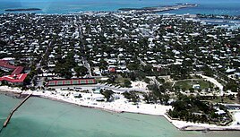
Aerial view of Key West (2001) Duval Street with St. Paul's Episcopal Church (2004) | |
| Nickname(s): "The Conch Republic” “Southernmost City in the Continental United States" | |
| Motto: One Human Family | |
 Location in Monroe County and the state of Florida | |
 U.S. Census Bureau map showing city limits | |
| Coordinates: 24°33′18″N 81°46′55″W / 24.55500°N 81.78194°W[1] | |
| Country | |
| State | |
| County | Monroe |
| Government | |
| • Type | Commission–Manager |
| • Mayor | Teri Johnston |
| • Commissioners | Jimmy Weekley, Lissette Carey, Samuel Kaufman, Mary Lou Hoover, Billy Wardlow, and Clayton Lopez |
| • City Manager | Albert Childress |
| • City Clerk | Keri O'Brien |
| • City Attorney | Ronald J. Ramsingh |
| Area | |
• Total | 7.21 sq mi (18.67 km2) |
| • Land | 5.60 sq mi (14.50 km2) |
| • Water | 1.61 sq mi (4.17 km2) |
| Elevation | 5 ft (2 m) |
| Population | |
• Total | 26,444 |
| • Density | 4,722.99/sq mi (1,823.44/km2) |
| Time zone | UTC−5 (Eastern (EST)) |
| • Summer (DST) | UTC−4 (EDT) |
| ZIP Codes | 33040, 33041, 33045 |
| Area codes | 305, 786, and 645 |
| FIPS code | 12-36550[4] |
| GNIS feature ID | 0294048[5] |
| Website | www |
Key West is an island in the Straits of Florida, within the U.S. state of Florida. Together with all or parts of the separate islands of Dredgers Key, Fleming Key, Sunset Key, and the northern part of Stock Island, it constitutes the City of Key West.
The island of Key West is about 4 miles (6 kilometers) long and 1 mile (2 km) wide, with a total land area of 4.2 square miles (11 km2).[6] Within Florida, it is 130 miles (210 km) southwest of Miami by air, about 165 miles (266 km) by road.[7] Key West is approximately 95 miles (153 km) north of Cuba at their closest points, and 106 miles (171 km) north-northeast of Havana.[8][9]
The city of Key West is the county seat of Monroe County, which includes a majority of the Florida Keys and part of the Everglades.[10][11] The total land area of the city is 5.6 square miles (14.5 km2).[12] The population within the city limits was 26,444 at the 2020 census.[3] The official city motto is "One Human Family".
Key West is the southernmost city in the contiguous United States and the westernmost island connected by highway in the Florida Keys. Duval Street, its main street, is 1.1 miles (1.8 km) in length in its 14-block-long crossing from the Gulf of Mexico to the Straits of Florida and the Atlantic Ocean. Key West is the southern terminus of U.S. Route 1 – the longest north–south road in the United States, as well as State Road A1A, the East Coast Greenway and, before 1935, the Florida East Coast Railway. Key West is a port of call for passenger cruise ships.[13] The Key West International Airport provides airline service. Naval Air Station Key West is an important year-round training site for naval aviation due to the tropical weather, which is also the reason Key West was chosen as the site of President Harry S. Truman's Winter White House. The central business district is located along Duval Street and includes much of the northwestern corner of the island.
- ^ a b Cite error: The named reference
GR1was invoked but never defined (see the help page). - ^ "2022 U.S. Gazetteer Files: Florida". United States Census Bureau. Retrieved January 18, 2023.
- ^ a b "P1. Race – Key West city, Florida: 2020 DEC Redistricting Data (PL 94-171)". U.S. Census Bureau. Retrieved January 18, 2023.
- ^ "U.S. Census website". United States Census Bureau. Retrieved January 31, 2008.
- ^ "US Board on Geographic Names". United States Geological Survey. October 25, 2007. Retrieved January 31, 2008.
- ^ "Key West City Information: Regional Setting". February 4, 2006. Archived from the original on December 24, 2013.
{{cite web}}: CS1 maint: unfit URL (link) - ^ Cite error: The named reference
chkdistwas invoked but never defined (see the help page). - ^ "ACME Mapper". ACME Labs.
Zoom out, drag map until the center pointer is on the Cuban coast, zoom in and adjust position, then click the 'Markers' button at bottom right of map. Units can be changed via the 'Options' button.
- ^ "Latitude/Longitude Distance Calculator". National Hurricane Center.
Coordinates used for Key West (the Whitehead Spit): 24.54410 (N), 81.80486 (W), and for Cuba (a headland just west of Santa Cruz del Norte): 23.18375 (N), 82.0003 (W).
- ^ "Find a County". National Association of Counties. Archived from the original on May 31, 2011. Retrieved June 7, 2011.
- ^ "Emerald Keys". Archived from the original on November 7, 2007.
- ^ "2016 U.S. Gazetteer Files". United States Census Bureau. Retrieved July 7, 2017.
- ^ Alvarez, Lizette (December 24, 2012). "Key West Looks at Identity as It Plots Tourism Future". The New York Times. Retrieved December 25, 2012.


