Back Xerson quberniyası Azerbaijani Херсонская губерня Byelorussian Херсонска губерния Bulgarian Gubèrnia de Kherson Catalan Gouvernement Cherson German Gobernación de Jersón Spanish Hersoni kubermang Estonian Hersonin kuvernementti Finnish Gouvernement de Kherson French Cherson Guwernement FRR
Kherson Governorate
Херсонская губерния | |
|---|---|
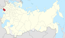
 Location in the Russian Empire | |
| Country | Russian Empire |
| Established | 1803 |
| Abolished | 1920 |
| Capital | Kherson |
| Area | |
| • Total | 71,936 km2 (27,775 sq mi) |
| Population (1897) | |
| • Total | 2,733,612 |
| • Density | 38/km2 (98/sq mi) |
| • Urban | 28.86% |
| • Rural | 71.14% |
Kherson Governorate,[a] known until 1803 as Nikolayev Governorate,[b] was an administrative-territorial unit (guberniya) of the Russian Empire, with its capital in Kherson. It encompassed 71,936 square kilometres (27,775 sq mi) in area and had a population of 2,733,612 inhabitants. At the time of the census in 1897, it bordered Podolia Governorate to the northwest, Kiev Governorate to the north, Poltava Governorate to the northeast, Yekaterinoslav Governorate to the east, Taurida Governorate to the southeast, Black Sea to the south, and Bessarabia Governorate to the west. It roughly corresponds to what is now most of Mykolaiv, Kirovohrad and Odesa Oblasts in Ukraine and some parts of Kherson and Dnipropetrovsk Oblasts.
The economy of the governorate was mainly based on agriculture. During the grain harvest, thousands of agricultural laborers from the parts of the Empire found work in the area. The industrial part of the economy, consisting primarily of flour milling, distilling, metalworking industry, iron mining, beet-sugar processing, and brick industry, was underdeveloped.

Cite error: There are <ref group=lower-alpha> tags or {{efn}} templates on this page, but the references will not show without a {{reflist|group=lower-alpha}} template or {{notelist}} template (see the help page).
