Back Islla de Kili AST Кілі Byelorussian Kili Island (munisipyo) CEB Kili-Insel German Kili Spanish جزیره کیلی Persian Kili (saari) Finnish Kili French Atol Kili Galician Kili Croatian
This article includes a list of general references, but it lacks sufficient corresponding inline citations. (August 2013) |
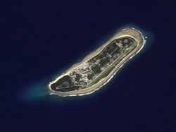
 NASA Astronaut Photography image of Kili Island | |
 Map of the island | |
| Geography | |
|---|---|
| Location | North Pacific |
| Coordinates | 5°38′46″N 169°07′42″E / 5.64611°N 169.12833°E |
| Archipelago | Ralik |
| Total islands | 1 |
| Area | 0.93 km2 (0.36 sq mi) |
| Highest elevation | 3 m (10 ft) |
| Administration | |
Marshall Islands | |
| Demographics | |
| Population | 415 (2021) |
| Ethnic groups | Marshallese |
image_map, map_image.Kili Island or Kili Atoll (Marshallese: Kōle, [kɤlʲe][1]) is a small, 81 hectares (200 acres) (0.93 square kilometers (0.36 sq mi)) island located in the Marshall Islands in the Pacific Ocean. As of 2021, 415 people lived on the island,[2] many of whom were descended from islanders who originally lived on Bikini Atoll. They were relocated when they agreed to let the U.S. government temporarily use their home for nuclear testing in 1945. Kili Island became their home after two prior relocations failed. The island does not have a natural lagoon and cannot produce enough food to enable the islanders to be self-sufficient. It is part of the legislative district of the Ralik Chain of the Marshall Islands. The island is approximately 48 kilometers (30 mi) southwest of Jaluit. It is a good sized island for the Marshall Islands, but it is not an atoll with a lagoon.
- ^ Marshallese-English Dictionary – Place Name Index
- ^ "Republic of the Marshall Islands 2021 Census Report, Volume 1: Basic Tables and Administrative Report" (PDF). Pacific Community (SPC): Statistics for Development Division. Pacific Community. May 30, 2023. Retrieved September 27, 2023.
