Back Klettgau (Gemeinde) ALS Клетгау Bulgarian Клетгау CE Klettgau CEB Klettgau (Gemeinde) German Δήμος Κλετγκάου Greek Klettgau Esperanto Klettgau Spanish Klettgau Basque کلتگاو Persian
You can help expand this article with text translated from the corresponding article in German. (February 2009) Click [show] for important translation instructions.
|
Klettgau | |
|---|---|
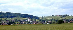
 View of Erzingen | |
Location of Klettgau within Waldshut district  | |
| Coordinates: 47°39′30″N 08°25′22″E / 47.65833°N 8.42278°E | |
| Country | Germany |
| State | Baden-Württemberg |
| Admin. region | Freiburg |
| District | Waldshut |
| Government | |
| • Mayor (2016–24) | Ozan Topcuogullari[1] |
| Area | |
| • Total | 45.87 km2 (17.71 sq mi) |
| Elevation | 409 m (1,342 ft) |
| Population (2022-12-31)[2] | |
| • Total | 7,611 |
| • Density | 170/km2 (430/sq mi) |
| Time zone | UTC+01:00 (CET) |
| • Summer (DST) | UTC+02:00 (CEST) |
| Postal codes | 79771 |
| Dialling codes | 07742 |
| Vehicle registration | WT |
| Website | www.klettgau.de |
Klettgau (High Alemannic: Chleggau) is a municipality in the district of Waldshut in Baden-Württemberg, Germany. It is the center of the Klettgau historical region stretching across the Swiss border into the cantons of Aargau, Schaffhausen and Zürich.
The municipal area includes the villages of Bühl, Erzingen, Geißlingen, Grießen, Rechberg, Riedern am Sand, and Weisweil.
- ^ Aktuelle Wahlergebnisse, Staatsanzeiger, accessed 15 September 2021.
- ^ "Bevölkerung nach Nationalität und Geschlecht am 31. Dezember 2022" [Population by nationality and sex as of December 31, 2022] (CSV) (in German). Statistisches Landesamt Baden-Württemberg. June 2023.


