Back কোদিয়াক দ্বীপ ব্যুরো, আলাস্কা BPY Kodiak Island Gông (Alaska) CDO Кадьяк-Айленд CE Kodiak Island Borough CEB Kodiak Island Borough, Alaska Welsh Kodiak Island Borough German Burgo de Isla Kodiak Spanish Kodiak Islandin piirikunta Finnish Borough de l'île Kodiak French Buirg Oileán Kodiak, Alasca Irish
Kodiak Island Borough | |
|---|---|
 | |
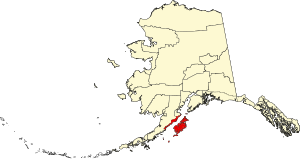
 Location within the U.S. state of Alaska | |
 Alaska's location within the U.S. | |
| Coordinates: 57°43′N 153°47′W / 57.71°N 153.78°W | |
| Country | |
| State | |
| Incorporated | September 24, 1963[1][2] |
| Named for | Kodiak Island |
| Seat | Kodiak |
| Largest city | Kodiak |
| Area | |
• Total | 12,022 sq mi (31,140 km2) |
| • Land | 6,550 sq mi (17,000 km2) |
| • Water | 5,472 sq mi (14,170 km2) 45.5% |
| Population (2020) | |
• Total | 13,101 |
• Estimate (2022) | 12,720 |
| • Density | 1.1/sq mi (0.42/km2) |
| Time zone | UTC−9 (Alaska) |
| • Summer (DST) | UTC−8 (ADT) |
| Congressional district | At-large |
| Website | www |
Kodiak Island Borough (Russian: Остров Кадьяк) is a borough in the U.S. state of Alaska. At the 2020 census, the population was 13,101, down from 13,592 in 2010.[3] The borough seat is Kodiak.[4]
- ^ "Government". Kodiak Island, AK - Official Website. Kodiak Island Borough. Retrieved May 4, 2012.
- ^ 1996 Alaska Municipal Officials Directory. Juneau: Alaska Municipal League/Alaska Department of Community and Regional Affairs. January 1996. p. 10.
- ^ "State & County QuickFacts". United States Census Bureau. Retrieved April 20, 2023.
- ^ "Find a County". National Association of Counties. Archived from the original on May 31, 2011. Retrieved June 7, 2011.
