Back Kokang Catalan Kokang Czech Kokang German Kokang French 果敢 GAN コーカン Japanese 코캉 Korean Kokang Portuguese Кокан (регион) Russian ᱠᱚᱠᱟᱝ SAT
Kokang
ကိုးကန့် / 果敢 | |
|---|---|
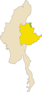
 Kokang Map during the 2009 Kokang incident | |
| Highest point | 2,548 m |
| Area | |
• Total | 1,895 km2 (732 sq mi) |
| Elevation | 1,000 m (3,000 ft) |
| Population (2009) | |
• Total | 150,000 |
| • Density | 79/km2 (210/sq mi) |
Special region 1 of the Union of Myanmar Kokang | |
|---|---|
| Anthem: 共赴榮昌 | |
 Area de facto controlled by Special region 1 | |
| Country | Myanmar |
| State | Shan State |
| Formation of the MNDAA and SR1–SS | 11 March 1989 |
| MNDAA lost power | August 2009 |
| MNDAA regain power | 5 January 2024 |
| Capital | Laukkai |
| Official languages | |
| Government | |
• Chairman | Peng Daxun |
• Vice Chairman | Li Laobao |
• Secretary-General | Song Kecheng |
| Area | |
• Total | 10,000 km2 (3,900 sq mi) |
| Highest elevation | 2,548 m (8,360 ft) |
| Population | |
• 2009 estimate | 150,000 |
| Currency | Renminbi |
| Time zone | UTC+6:30 (MMT) |
| Driving side | right |
| Calling code | +86 (0)883 |

Kokang (Burmese: ကိုးကန့်; Chinese: 果敢; pinyin: Guǒgǎn; Wade–Giles: Kuo-kan) is a region in Myanmar. It is located in the northern part of Shan State, with the Salween River to its west, and sharing a border with China's Yunnan Province to the east. Its total land area is around 1,895 square kilometers (732 sq mi).[1] The capital is Laukkai. Kokang is mostly populated by Kokang Chinese, a Han Chinese group living in Myanmar.
Kokang had been historically part of China for several centuries and is still claimed by the Republic of China to this day, but was largely left alone by successive governments due to its remote location. The region formed a de facto buffer zone between Yunnan province and the Shan States.[2] The Yang clan, originally Ming loyalists from Nanjing, consolidated the area into a single polity. In 1840, the Yunnan governor granted the Yang clan the hereditary rights as a vassal of the Qing dynasty.[2] After the British conquest of Upper Burma in 1885, Kokang was initially placed in China under the 1894 Sino-British boundary convention. It was ceded to British Burma in a supplementary agreement signed in February 1897.[3]
From the 1960s to 1989, the area was controlled by the Communist Party of Burma, and after the party's armed wing disbanded in 1989 it became a special region of Myanmar under the control of the Myanmar Nationalities Democratic Alliance Army (MNDAA). Armed conflicts between the MNDAA and the Tatmadaw have resulted in the 2009 Kokang incident and the 2015 Kokang offensive.
- ^ Cite error: The named reference
crossintowas invoked but never defined (see the help page). - ^ a b Lintner, Bertil (1999). Burma in Revolt: Opium and Insurgency since 1948. Silkworm Books. p. 60. ISBN 978-1-63041-184-8.
- ^ Kratoska, Paul H. (13 May 2013). Southeast Asian Minorities in the Wartime Japanese Empire. Routledge. p. 40. ISBN 978-1-136-12514-0.

