Back Krisjna (rivier) Afrikaans कृष्णा नदी ANP نهر كريشنا Arabic نهر كريشنا ARZ Ríu Krishná AST کریشنا چایی AZB Кришна (йылға) Bashkir Крышна (рака) Byelorussian Кришна (река) Bulgarian कृष्णा नदी Bihari
| Krishna River | |
|---|---|
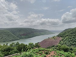
 Krishna River gorge by Srisailam, Andhra Pradesh, India | |
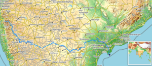
 Path of the Krishna in the peninsular India ([1]) | |
| Location | |
| Country | India |
| State | Maharashtra, Karnataka, Telangana, Andhra Pradesh |
| Region | South India |
| Physical characteristics | |
| Source | Near Mahabaleshwar, Jor village, Dist- Satara |
| • location | Satara district, Maharashtra, India |
| • coordinates | 17°59′19″N 73°38′17″E / 17.98861°N 73.63806°E |
| • elevation | 914 m (2,999 ft) Geographic headwaters |
| Mouth | Bay Of Bengal |
• location | Hamsaladeevi, Krishna district, Andhra Pradesh, India |
• coordinates | 15°44′06″N 80°55′12″E / 15.73500°N 80.92000°E[1] |
• elevation | 0 m (0 ft) |
| Length | 1,400 km (870 mi) or 1,290 km (800 mi)approx.[2] |
| Basin size | 258,948 km2 (99,980 sq mi) |
| Discharge | |
| • average | 2,213 m3/s (78,200 cu ft/s) |
| Discharge | |
| • location | Vijayawada (1901–1979 average), max (2024), min (1997) |
| • average | 1,641.74 m3/s (57,978 cu ft/s) |
| • minimum | 13.52 m3/s (477 cu ft/s) |
| • maximum | 33,413.88 m3/s (1,180,000 cu ft/s)[3][4] |
| Basin features | |
| Tributaries | |
| • left | Yerla, Bhima, Dindi, Musi, Paleru, Munneru |
| • right | Kudali (Niranjna) Venna, Koyna, Panchganga, Dudhaganga, Ghataprabha, Malaprabha, Tungabhadra |
The Krishna River in the Deccan plateau is the third-longest river in India, after the Ganga and Godavari. It is also the fourth-largest in terms of water inflows and river basin area in India, after the Ganges, Indus and Godavari.[5] The river, also called Krishnaveni, is 1,400 kilometres (870 mi) long and its length in Maharashtra is 282 kilometres.[6] It is a major source of irrigation in the Indian states of Maharashtra, Karnataka, Telangana and Andhra Pradesh.[7]
- ^ Krishna at GEOnet Names Server
- ^ "Home | Know India: National Portal of India". Archived from the original on 19 August 2017.
- ^ Jonathan, P. Samuel (15 August 2019). "For Krishna river, it's always October". The Hindu. Archived from the original on 7 November 2020. Retrieved 19 August 2019.
- ^ Apparasu, Srinivasa Rao (3 September 2024). "1.18 million cusecs of water released from barrage inundates parts of Vijaywada". Hindustan Times. Retrieved 11 September 2024.
- ^ "River Basins of India". Archived from the original on 27 June 2022. Retrieved 7 May 2022.
- ^ Havale, Professor Baliram. Lakshyawedha Samany dnyan/ G.K part – 1 (in Marathi). Aurangabad, India: Sahyadri Publication. p. 72.
- ^ "Map of Krishna River basin" (PDF). Archived (PDF) from the original on 6 August 2017. Retrieved 27 March 2015.The Krishna is the second largest east flowing peninsular river. It originates near Mahabaleshwar, Jor village (Sahayadri), Maharastra. It flows through Karnataka before entering Telangana.