| Kronhuset | |
|---|---|
 | |
 | |
| General information | |
| Architectural style | Dutch |
| Classification | Arsenal, Granary, Chapel, Museum |
| Location | Gothenburg, Sweden |
| Address | Kronhusgatan 1D 411 13 Göteborg Västra Götalands län |
| Coordinates | 57°42′28″N 11°57′49″E / 57.70778°N 11.96361°E |
| Construction started | 1643 |
| Completed | 1654 |
| Owner | Gothenburg Municipality, managed by Higab |
| Technical details | |
| Material | Brick |
| Design and construction | |
| Architect(s) | Simon de la Vallée |
| Website | |
| 21400000231338, Riksantikvarieämbetet. | |
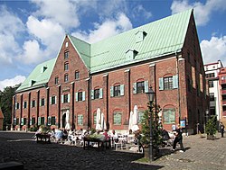
Kronhuset ('the Crown House' in English), formerly known as Giötheborgz Tyghuhs ('Gothenburg's Arsenal'),[1] is a redbrick building in Västra Nordstaden in Gothenburg.[2] It was constructed during the years 1643–1654 in a Dutch style, and is Gothenburg's joint-oldest secular building along with the Torstenson Palace (constructed 1648–1650). The royal architect Simon de la Vallée is believed to have designed the building.[3] The Kronhus was originally used as an arsenal for the city garrison and as a granary to store food reserves so that the city could survive a siege.[3] On December 9, 1927, the ownership of Kronhuset passed from the Swedish state to Gothenburg Municipality.[4] It has been a byggnadsminne, a listed building, since 24 October 1968.[5]
- ^ Göteborg genom tre sekler, doktor Maja Kjellin, Bokförlaget Forum AB, Stockholm 1950 p.24
- ^ Kronhuset, map from Lantmäteriet.
- ^ a b Antologia Gothoburgensis: det är en bok i ord och bilder om Göteborg genom tiderna skildrad av samtida författare och konstnärer jämte kronologiska anteckningar om viktigare händelser i staden från dess grundläggning, Folke Persson, Agne Rundqvist, Arvid Flygare, Maja Kjellin, Stig Roth, Rundqvists Boktryckeri, Göteborg 1953 pp. 52-55
- ^ Svenska Dagbladets årsbok : 1927, red. Erik Rudberg & Edvin Hellblom, Stockholm 1928, p. 45
- ^ "Kronhuset", Bebyggelseregistret, Riksantikvarieämbetet.
