Back لادرا، کالیفورنیا AZB Ладера (Калифорни) CE Ladera CEB Ladera (California) Spanish Ladera (Kalifornia) Basque لادرا، کالیفرنیا Persian Ladera (Californie) French Ladera (Kalifornija) Croatian Ladera Italian Ladera (California) LLD
Ladera | |
|---|---|
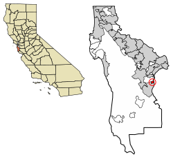
 Location of Ladera in San Mateo County, California. | |
| Coordinates: 37°23′58″N 122°11′50″W / 37.39944°N 122.19722°W | |
| Country | United States |
| State | California |
| County | San Mateo |
| Government | |
| • Type | Community Association |
| Area | |
• Total | 0.443 sq mi (1.146 km2) |
| • Land | 0.443 sq mi (1.146 km2) |
| • Water | 0 sq mi (0 km2) 0% |
| Elevation | 315 ft (96 m) |
| Population (2020) | |
• Total | 1,557 |
| • Density | 3,500/sq mi (1,400/km2) |
| Time zone | UTC-8 (Pacific (PST)) |
| • Summer (DST) | UTC-7 (PDT) |
| ZIP codes | 94028 |
| Area code | 650 |
| FIPS code | 06-39094 |
| GNIS feature ID | 2628745 |
| [2] | |
Ladera is a census-designated place (CDP) in southern San Mateo County, California,[2] adjacent to Portola Valley. Primarily a residential community, it comprises approximately 520 homes, governed by the Ladera Community Association. The ZIP Code is 94028 and the community is inside area code 650. The population was 1,557 at the 2020 census.

