Back لاندسات 8 Arabic Landsat 8 German Landsat 8 Spanish لندست ۸ Persian Landsat 8 French Landsat 8 Hungarian Landsat 8 ID ランドサット8号 Japanese Landsat 8 Latvian/Lettish Landsat 8 Polish
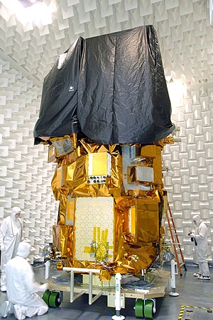
 Landsat 8 during ground testing | |
| Names | Landsat Data Continuity Mission |
|---|---|
| Mission type | Satellite imagery |
| Operator | NASA / USGS |
| COSPAR ID | 2013-008A |
| SATCAT no. | 39084 |
| Website | [1] |
| Mission duration | 5 years (planned) 10 years (with fuel) Elapsed: 11 years, 9 months, 3 days |
| Spacecraft properties | |
| Spacecraft | Landsat 8 |
| Spacecraft type | LEOStar |
| Bus | LEOStar-3 |
| Manufacturer | Orbital Sciences (prime) Ball Aerospace (OLI) NASA GSFC (TIRS) |
| Launch mass | 2,623 kg (5,783 lb) |
| Dry mass | 1,512 kg (3,333 lb) |
| Start of mission | |
| Launch date | 11 February 2013, 18:02:00 UTC |
| Rocket | Atlas V 401 (AV-035) |
| Launch site | Vandenberg, SLC-3E |
| Contractor | United Launch Alliance |
| Entered service | 30 May 2013 |
| Orbital parameters | |
| Reference system | Geocentric orbit[1] |
| Regime | Sun-synchronous orbit |
| Altitude | 705 km |
| Inclination | 98.22° |
| Period | 98.8 minutes |
| Instruments | |
| Operational Land Imager (OLI) Thermal Infrared Sensor (TIRS) | |
 Landsat Data Continuity Mission (LDCM) mission patch | |
Landsat 8 is an American Earth observation satellite launched on 11 February 2013. It is the eighth satellite in the Landsat program; the seventh to reach orbit successfully. Originally called the Landsat Data Continuity Mission (LDCM), it is a collaboration between NASA and the United States Geological Survey (USGS). NASA Goddard Space Flight Center in Greenbelt, Maryland, provided development, mission systems engineering, and acquisition of the launch vehicle while the USGS provided for development of the ground systems and will conduct on-going mission operations. It comprises the camera of the Operational Land Imager (OLI) and the Thermal Infrared Sensor (TIRS), which can be used to study Earth surface temperature and is used to study global warming.[2]
The satellite was built by Orbital Sciences Corporation, who served as prime contractor for the mission.[3] The spacecraft's instruments were constructed by Ball Aerospace & Technologies and NASA's Goddard Space Flight Center (GSFC),[4] and its launch was contracted to United Launch Alliance (ULA).[5] During the first 108 days in orbit, LDCM underwent checkout and verification by NASA and on 30 May 2013 operations were transferred from NASA to the USGS when LDCM was officially renamed to Landsat 8.[6]
- ^ "Landsat 8 Orbit". Heavens Above. 28 May 2016. Retrieved 28 May 2016.
- ^ Li, Rita Yi Man; Chau, Kwong Wing; Li, Herru Ching Yu; Zeng, Fanjie; Tang, Beiqi; Ding, Meilin (2021). Ahram, Tareq (ed.). "Remote Sensing, Heat Island Effect and Housing Price Prediction via AutoML". Advances in Artificial Intelligence, Software and Systems Engineering. Advances in Intelligent Systems and Computing. Cham: Springer International Publishing: 113–118. doi:10.1007/978-3-030-51328-3_17. ISBN 978-3-030-51328-3.
- ^ "Fact Sheet - LDCM Earth Image Collection Satellite" (PDF). Orbital Sciences Corporation. Retrieved 12 February 2013.
- ^ "LDCM Spacecraft". NASA. Retrieved 12 February 2013.
 This article incorporates text from this source, which is in the public domain.
- ^ "United Launch Alliance Successfully Launches Second NASA Payload in Just 12 Days". United Launch Alliance. 11 February 2013. Archived from the original on 7 December 2013. Retrieved 12 February 2013.
- ^ "Landsat 8 Satellite Begins Watch". NASA. 30 May 2013.
 This article incorporates text from this source, which is in the public domain.