Back Lecques BUG Lècas Catalan Лек (ГагӀ) CE Lecques CEB Lecques German Λεκ (Γκαρ) Greek Lecques Esperanto Lecques Spanish Lecques Basque Lecques French
Lecques | |
|---|---|
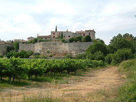
 View of Lecques from the south | |
| Coordinates: 43°50′16″N 4°03′50″E / 43.8378°N 4.0639°E | |
| Country | France |
| Region | Occitania |
| Department | Gard |
| Arrondissement | Nîmes |
| Canton | Calvisson |
| Intercommunality | Pays de Sommières |
| Government | |
| • Mayor (2020–2026) | Bernadette Poher[1] |
| Area 1 | 5.2 km2 (2.0 sq mi) |
| Population (2021)[2] | 456 |
| • Density | 88/km2 (230/sq mi) |
| Time zone | UTC+01:00 (CET) |
| • Summer (DST) | UTC+02:00 (CEST) |
| INSEE/Postal code | 30144 /30250 |
| Elevation | 26–111 m (85–364 ft) (avg. 50 m or 160 ft) |
| 1 French Land Register data, which excludes lakes, ponds, glaciers > 1 km2 (0.386 sq mi or 247 acres) and river estuaries. | |
Lecques (French pronunciation: [lɛk]; Occitan: Lècas) is a commune in the Gard department in southern France.
It is built on rising ground, on the west bank of the River Vidourle, 6 km (3.7 mi) to the north and upstream of Sommières. The village centre is on a rocky outcrop that overhangs the bank of the river.[3] Steps lead down to the bridge. Its elevation means it is protected from the 'vidourlades' or violent floods, for example, that of 9 September 2002.[4] There are remains of the ramparts, the narrow medieval streets and a church.
- ^ "Répertoire national des élus: les maires" (in French). data.gouv.fr, Plateforme ouverte des données publiques françaises. 4 May 2022.
- ^ "Populations légales 2021" (in French). The National Institute of Statistics and Economic Studies. 28 December 2023.
- ^ Interpretation board erected by the Intercommunality
- ^ Interpretation board erected by the Syndicat interdepartmental d'Aménagement du Vidoule


