Back Lena Afrikaans Lena (Fluss) ALS نهر لينا Arabic واد لينا ARY نهر لينا ARZ Ríu Lena AST Lena AVK Lena çayı Azerbaijani لنا چایی AZB Лена Bashkir
| Lena | |
|---|---|
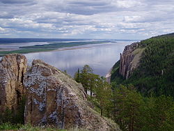
 The Lena Pillars along the river near Yakutsk | |
 Lena watershed | |
| Native name | |
| Location | |
| Country | Russia |
| Physical characteristics | |
| Source | Baikal Mountains |
| • location | Kachugsky District, Irkutsk Oblast |
| • coordinates | 53°58′3″N 107°52′56″E / 53.96750°N 107.88222°E (approximately) |
| • elevation | 1,640 m (5,380 ft) |
| Mouth | Lena Delta |
• location | Arctic Ocean, Laptev Sea |
• coordinates | 72°24′31″N 126°41′05″E / 72.4087°N 126.6847°E |
• elevation | 0 m (0 ft) |
| Length | 4,294 km (2,668 mi) |
| Basin size | 2,460,742 km2 (950,098 sq mi) to 2,490,000 km2 (960,000 sq mi) |
| Width | |
| • maximum | 10,000 m (33,000 ft) |
| Depth | |
| • maximum | 28 m (92 ft) |
| Discharge | |
| • location | Kyusyur, Russia (Basin size: 2,440,000 km2 (940,000 sq mi) to 2,418,974 km2 (933,971 sq mi)[1] |
| • average | (Period of data: 1971-2015)17,773 m3/s (627,600 cu ft/s)[1]
(Period of data: 1970-1999)17,067 m3/s (602,700 cu ft/s)[2] 15,500 m3/s (550,000 cu ft/s)[3] |
| • minimum | 366 m3/s (12,900 cu ft/s) |
| • maximum | 241,000 m3/s (8,500,000 cu ft/s)
Lena Delta, Laptev Sea, Russia (Period of data: 1984-2018)577 km3/a (18,300 m3/s)[1] (Period of data: 1940-2019) 545.7 km3/a (17,290 m3/s)[4] |
| Discharge | |
| • location | Vilyuy |
| • average | 12,100 m3/s (430,000 cu ft/s)
Tabaga, Yakutsk (Basin size: 987,000 km2 (381,000 sq mi) (Period of data: 1967-2017) 7,453.2 m3/s (263,210 cu ft/s)[5](max. 51,600 m3/s (1,820,000 cu ft/s))[5] |
| Discharge | |
| • location | Olyokminsk |
| • average | 4,500 m3/s (160,000 cu ft/s) |
| Discharge | |
| • location | Vitim |
| • average | 1,700 m3/s (60,000 cu ft/s) |
| Discharge | |
| • location | Kirensk |
| • average | 480 m3/s (17,000 cu ft/s) |
| Basin features | |
| Tributaries | |
| • left | Vilyuy |
| • right | Kirenga, Vitim, Olyokma, Aldan |
 | |
The Lena is a river in the Russian Far East and is the easternmost river of the three, great rivers of Siberia, including the River Ob and the River Yenisey, which flow into the Arctic Ocean. [note 1] The Lena river is 4,294 km (2,668 mi) long and has a capacious drainage basin of 2,490,000 km2 (960,000 sq mi); thus the Lena is the eleventh-longest river in the world and the longest river entirely within Russia.[6] Geographically, permafrost is the type of soil that underlies most of the Lena river's catchment, twenty per cent (20%) of which is continuous.
- ^ a b c Stadnyk, Tricia A.; Tefs, A.; Broesky, M.; Déry, S. J.; Myers, P. G.; Ridenour, N. A.; Koenig, K.; Vonderbank, L.; Gustafsson, D. (28 May 2021). "Changing freshwater contributions to the Arctic". Elementa: Science of the Anthropocene. 9 (1): 00098. Bibcode:2021EleSA...9...98S. doi:10.1525/elementa.2020.00098. S2CID 236682638.
- ^ "Variations of the Present-Day Annual and Seasonal Runoff in the Far East and Siberia with the Use of Regional Hydrological and Global Climate Models" (PDF). 2018.
- ^ http://www.abratsev.narod.ru/biblio/sokolov/p1ch23b.html, Sokolov, Eastern Siberia // Hydrography of USSR. (in russian)
- ^ "River Discharge".
- ^ a b Gautier, Emmanuèle; Dépret, Thomas; Cavero, Julien; Costard, François; Virmoux, Clément; Fedorov, Alexander; Konstantinov, Pavel; Jammet, Maël; Brunstein, Daniel (August 2021). "Fifty-year dynamics of the Lena River islands (Russia): Spatio-temporal pattern of large periglacial anabranching river and influence of climate change". Science of the Total Environment. 783: 147020. Bibcode:2021ScTEn.78347020G. doi:10.1016/j.scitotenv.2021.147020. PMID 34088165. S2CID 234836524.
- ^ "Река Лена in the State Water Register of Russia". textual.ru (in Russian).
Cite error: There are <ref group=note> tags on this page, but the references will not show without a {{reflist|group=note}} template (see the help page).