Back ليومنستر (ماساتشوستس) Arabic يومنستر ARZ لئومینستر، ماساچوست AZB Лиоминстър (Масачузетс) Bulgarian Leominster (Massachusetts) Catalan Леменстер (Массачусетс) CE Leominster (lungsod sa Tinipong Bansa) CEB Leominster, Massachusetts Welsh Leominster DAG Leominster (Massachusetts) German
Leominster, Massachusetts | |
|---|---|
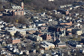
 Downtown Leominster | |
| Nickname(s): | |
| Motto(s): We Must, We Can and We Will Be Free. | |
 Location in Worcester County and the state of Massachusetts | |
Location in the United States of America | |
| Coordinates: 42°31′30″N 71°45′37″W / 42.52500°N 71.76028°W | |
| Country | United States |
| State | Massachusetts |
| County | Worcester |
| Settled | 1640 |
| Incorporated |
|
| Government | |
| • Type | Mayor-council city |
| • Mayor | Dean J. Mazzarella |
| • City Council |
|
| • School Committee |
|
| Area | |
| • Total | 29.68 sq mi (76.87 km2) |
| • Land | 28.82 sq mi (74.65 km2) |
| • Water | 0.86 sq mi (2.22 km2) |
| Elevation | 400 ft (123 m) |
| Population (2022)census.gov | |
| • Total | 43,646 |
| • Density | 1,519.00/sq mi (586.49/km2) |
| Time zone | UTC−5 (Eastern) |
| • Summer (DST) | UTC−4 (Eastern) |
| ZIP Code | 01453 |
| Area code | 508/978 |
| FIPS code | 25-35075 |
| GNIS feature ID | 0617697 |
| Website | www.leominster-ma.gov |
Leominster (/ˈlɛmənstər/ LEM-ən-stər) is a city in Worcester County, Massachusetts, United States. It is the second-largest city in Worcester County, with a population of 43,222[3] at the 2023 census.[4] Leominster is located north of Worcester and northwest of Boston. Both Route 2 and Route 12 pass through Leominster. Interstate 190, Route 13, and Route 117 all have starting/ending points in Leominster. Leominster is bounded by Fitchburg and Lunenburg to the north, Lancaster to the east, Sterling and Princeton to the south, and Westminster to the west.
Cite error: There are <ref group=lower-alpha> tags or {{efn}} templates on this page, but the references will not show without a {{reflist|group=lower-alpha}} template or {{notelist}} template (see the help page).
- ^ Pan Am's World, the USA: everything you need to know about 50 great States. Pan American World Airways. 1975. p. 46.
- ^ "2020 U.S. Gazetteer Files". United States Census Bureau. Archived from the original on May 28, 2022. Retrieved May 21, 2022.
- ^ "Leominster, Massachusetts Population 2024". worldpopulationreview.com. Retrieved January 10, 2024.
- ^ "Census - Geography Profile: Leominster city, Massachusetts". Retrieved September 25, 2021.


