Back Lihou Breton Lihou Catalan Lihou Island (pulo sa Gernsiy) CEB Lihou Welsh Lihou German Lihou Spanish Lihou French Lihou Scots/Gaelic Lihou Galician ליהו HE
 Lihou and the nearby L'Eree headland of Guernsey | |
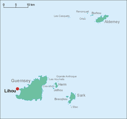
 Lihou is on the far left of the map | |
| Geography | |
|---|---|
| Coordinates | 49°27′40″N 2°40′04″W / 49.46111°N 2.66778°W |
| Archipelago | Channel Islands |
| Adjacent to | English Channel |
| Area | 36 acres (15 ha)[1] |
| Administration | |
| Demographics | |
| Population | 1 (Warden) [2] |
| Additional information | |
| Official website | www |
| Official name | Lihou Island and l'Erée Headland, Guernsey |
| Designated | 1 March 2006 |
| Reference no. | 1608[3] |

Lihou (/ˈliːuː/) is a small tidal island located just off the west coast of the island of Guernsey, in the English Channel, between Great Britain and France. Administratively, Lihou forms part of the Parish of St. Peter's in the Bailiwick of Guernsey,[1] and is now owned by the parliament of Guernsey (the States of Guernsey), although there have been a number of owners in the past.[5] Since 2006, the island has been jointly managed by the Guernsey Environment Department and the Lihou Charitable Trust. In the past the island was used by locals for the collection of seaweed for use as a fertiliser, but today Lihou is mainly used for tourism, including school trips. Lihou is also an important centre for conservation, forming part of a Ramsar wetland site for the preservation of rare birds and plants as well as historic ruins of a priory and a farmhouse.
- ^ a b Equivalent to 89 vergées, a local measure of area. See Guernsey Facts and Figures (PDF). States of Guernsey. 2006. p. 3. Retrieved 2 February 2014.
- ^ "The Channel Islands". Whitaker's Concise Almanack 2012 (144 ed.). Bloomsbury Publishing. 2011. p. 314. ISBN 9781408142301.
- ^ "Lihou Island and l'Erée Headland, Guernsey". Ramsar Sites Information Service. Retrieved 25 April 2018.
- ^ Yves Le Marquand (19 August 2019). "Lihou can fly own flag". Guernsey Press. Retrieved 31 August 2024.
- ^ Cite error: The named reference
lihouislandwas invoked but never defined (see the help page).