Back Lincolnshire Afrikaans Lincolnscīr ANG لنكولنشاير Arabic لنكولنشاير ARZ Lincolnshire AST Lincolnshire BAN Лінкальншыр Byelorussian Лінкальншыр BE-X-OLD Линкълншър Bulgarian লিঙ্কোনশায়ার Bengali/Bangla
Lincolnshire | |
|---|---|
| Motto(s): "Land and God" | |
 Lincolnshire within England | |
| Coordinates: 53°06′N 0°12′W / 53.1°N 0.2°W | |
| Sovereign state | United Kingdom |
| Constituent country | England |
| Region | Divided between East Midlands & Yorkshire and the Humber |
| Established | April 1996 |
| Established by | 1990s local government reform |
| Preceded by | Humberside (North East Lincolnshire & North Lincolnshire) & Lincolnshire (Lincolnshire County Council) |
| Origin | Parts of Lincolnshire (Grimsby County Borough, Holland, Kesteven, Lincoln County Borough & Lindsey) |
| Time zone | UTC+0 (GMT) |
| • Summer (DST) | UTC+1 (BST) |
| UK Parliament | 11 MPs |
| Police | Humberside Police (North East Lincolnshire & North Lincolnshire Areas) & Lincolnshire Police (Lincolnshire County Council Area) |
| Ceremonial county | |
| Lord Lieutenant | Toby Dennis |
| High Sheriff | Michael Scott[1] (2020–21) |
| Area | 6,977 km2 (2,694 sq mi) |
| • Rank | 2nd of 48 |
| Population (2022)[2] | 1,103,320 |
| • Rank | 19th of 48 |
| Density | 158/km2 (410/sq mi) |
| Non-metropolitan county | |
| County council | Lincolnshire County Council |
| Control | Conservative |
| Admin HQ | Lincoln |
| Area | 5,937 km2 (2,292 sq mi) |
| • Rank | 2nd of 21 |
| Population (2022)[3] | 775,524 |
| • Rank | 13th of 21 |
| Density | 131/km2 (340/sq mi) |
| ISO 3166-2 | GB-LIN |
| GSS code | E10000019 |
| ITL | TLF30 |
| Website | lincolnshire |
| Districts | |
 Districts of Lincolnshire Unitary County council area | |
| Districts | |
Lincolnshire (/ˈlɪŋkənʃər, -ʃɪər/), abbreviated Lincs, is a ceremonial county in the East Midlands and Yorkshire and the Humber regions of England. It is bordered by the East Riding of Yorkshire across the Humber estuary to the north, the North Sea to the east, Norfolk, Cambridgeshire, Northamptonshire and Rutland to the south, and Leicestershire, Nottinghamshire and South Yorkshire to the west. The county town is the city of Lincoln. Lincolnshire is the second largest ceremonial county in England, after North Yorkshire.
The county is predominantly rural, with an area of 6,959 km2 (2,687 sq mi) and a population of 1,095,010. After Lincoln (104,565), the largest towns are Grimsby (85,911) and Scunthorpe (81,286).[4] For local government purposes Lincolnshire comprises a non-metropolitan county, with seven districts, and the unitary authority areas of North Lincolnshire and North East Lincolnshire. The last two areas are part of the Yorkshire and the Humber region, and the rest of the county is in the East Midlands.
The county has a varied geography. The south-west contains part of the Fens, a naturally marshy region which has been drained for agriculture, and the south-east is an upland region.[5][6] A wide vale runs north-south from the centre to the north of the county.[7][8] To its east, the chalk hills of the Lincolnshire Wolds,[9] which have been designated a national landscape,[10] occupy the north-east, with a coastal plain and the Lincolnshire Marsh beyond.[11] The west of the vale is demarcated by the Lincolnshire Edge, a long escarpment; at its northern end are the Coversands, an area of heath.[12][13] Beyond the edge, the western border of the county contains the eastern part of the Trent Valley and, in the north, part of the Humberhead Levels,[14][15] with the River Trent itself forming part of the border.
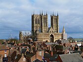
Lincolnshire has had a comparatively quiet history, being a rural county which was not heavily industrialised and faced little threat of invasion. In the Roman era Lincoln was a major settlement, called Lindum Colonia. In the fifth century what would become the county was settled by the invading Angles, who established the Kingdom of Lindsey in the north of the region. Lincoln became the centre of a diocese in 1072, and Lincoln Cathedral was built over the following centuries. The late Middle Ages were a particularly prosperous period, when wealth from wool trade facilitated the building of grand churches such as St Botolph's Church, Boston. During the Second World War the relatively flat topography of the county made it an important base for the Royal Air Force, which built several airfields and based two bomber squadrons in the area.
- ^ "No. 62943". The London Gazette. 13 March 2020. p. 5161.
- ^ "Mid-2022 population estimates by Lieutenancy areas (as at 1997) for England and Wales". Office for National Statistics. 24 June 2024. Retrieved 26 June 2024.
- ^ "Mid-Year Population Estimates, UK, June 2022". Office for National Statistics. 26 March 2024. Retrieved 3 May 2024.
- ^ "Towns and cities, characteristics of built-up areas, England and Wales - Office for National Statistics". www.ons.gov.uk. Retrieved 10 December 2023.
- ^ "The Fens". National Character Areas. Retrieved 26 September 2024.
- ^ "Kesteven Uplands". National Character Areas. Retrieved 26 September 2024.
- ^ "Lincolnshire Wolds". National Character Areas. Retrieved 26 September 2024.
- ^ "Central Lincolnshire Vale". National Character Areas. Retrieved 26 September 2024.
- ^ "Lincolnshire Wolds". National Character Areas. Retrieved 26 September 2024.
- ^ "Lincolnshire Wolds". Lincolnshire Wolds Countryside Service. Retrieved 26 September 2024.
- ^ "Lincolnshire Coast and Marshes". National Character Areas. Retrieved 26 September 2024.
- ^ "Northern Lincolnshire Edge with Coversands". National Character Areas. Retrieved 26 September 2024.
- ^ "Southern Lincolnshire Edge". National Character Area. Retrieved 26 September 2024.
- ^ "Humberhead Levels". National Character Areas. Retrieved 26 September 2024.
- ^ "Trent and Belvoir Vales". National Character Areas. Retrieved 26 September 2024.


