Back ليندوس Arabic ليندوس ARZ Llindos AST Lindos Catalan Líndos CEB Lindos Czech Lindos Welsh Lindos Danish Lindos German Λίνδος Greek
Lindos
Λίνδος | |
|---|---|
 Aerial view of Lindos | |
| Coordinates: 36°05′N 28°05′E / 36.083°N 28.083°E | |
| Country | Greece |
| Administrative region | South Aegean |
| Regional unit | Rhodes |
| Area | |
| • Municipal unit | 178.9 km2 (69.1 sq mi) |
| Highest elevation | 5 m (16 ft) |
| Lowest elevation | 0 m (0 ft) |
| Population (2021)[1] | |
| • Municipal unit | 4,496 |
| • Municipal unit density | 25/km2 (65/sq mi) |
| • Community | 1,096 |
| Time zone | UTC+2 (EET) |
| • Summer (DST) | UTC+3 (EEST) |
| Postal code | 851 07 |
| Area code(s) | 22440 |
| Vehicle registration | ΚΧ, ΡΟ, ΡΚ |
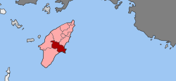
Lindos (/ˈlɪndɒs/; ‹See Tfd›Greek: Λίνδος) is an archaeological site, a fishing village and a former municipality on the island of Rhodes, in the Dodecanese, Greece. Since the 2011 local government reform, it is part of the municipality Rhodes, of which it is a municipal unit.[2] The municipal unit has an area of 178.9 km2.[3] It lies on the east coast of the island. It is about 40 km south of the city of Rhodes and its fine beaches make it a popular tourist and holiday destination. Lindos is situated in a large bay and faces the fishing village and small resort of Charaki.
- ^ "Αποτελέσματα Απογραφής Πληθυσμού - Κατοικιών 2021, Μόνιμος Πληθυσμός κατά οικισμό" [Results of the 2021 Population - Housing Census, Permanent population by settlement] (in Greek). Hellenic Statistical Authority. 29 March 2024.
- ^ "ΦΕΚ B 1292/2010, Kallikratis reform municipalities" (in Greek). Government Gazette.
- ^ "Population & housing census 2001 (incl. area and average elevation)" (PDF) (in Greek). National Statistical Service of Greece. Archived from the original (PDF) on 2015-09-21.

