Back Liste der Gemeinden in Nunavut German Luettelo Nunavutin kunnista Finnish Lista de municipalitates de Nunavut Interlingua Lista di munisipionan di Nunavut PAP Lista de municípios de Nunavut Portuguese Список муниципалитетов Нунавута Russian 努納福特地區市鎮列表 Chinese
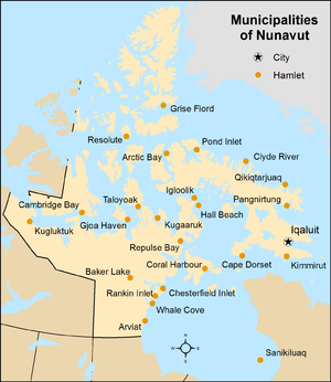
Nunavut is the least populous of Canada's three territories with 36,858 residents as of 2021 Canadian census, but the largest territory in land area, at 1,836,993.78 km2 (709,267.26 sq mi).[1] Nunavut is also larger than any of Canada's ten provinces.[1] Nunavut's 25 municipalities cover only 0.2% of the territory's land mass, but are home to 99.95% of its population. The remaining 99.8% of Nunavut's land mass comprises three small unincorporated settlements (0.015%) and three vast unorganized areas (99.796%).[2] As of 2021, no people were recorded as living in the unincorporated areas of Kitikmeot, Unorganized and Qikiqtaaluk, Unorganized, while a total of 18 were listed in Kivalliq, Unorganized.[3][4][5][6][7][8]
Municipalities are created by the Government of Nunavut in accordance with the Cities, Towns and Villages Act (CTVA)[9] and the Hamlets Act.[10] According to the CTVA, a municipality is an "area within the boundaries of a municipal corporation, as described in the order establishing or continuing the municipal corporation" where a municipal corporation is either a city, town or village.[9] According to the Hamlets Act, a municipality is similarly an "area within the boundaries of a hamlet, as described in the order establishing or continuing the hamlet". All of Nunavut's 25 municipalities are hamlets except for the City of Iqaluit,[5] which is the territory's capital.
The largest municipality by population in Nunavut is the capital city, Iqaluit, with 7,429 residents, home to 20.2% of the territory's population.[3] The smallest municipality by population is Grise Fiord with 144 residents.[3] The largest municipality by land area is Kugluktuk, which spans 538.99 km2 (208.11 sq mi), while the smallest is Kimmirut at 2.3 km2 (0.89 sq mi).[3]
- ^ a b "Population and dwelling counts, for Canada, provinces and territories, 2021 and 2016 censuses – 100% data". Statistics Canada. March 14, 2022. Retrieved March 14, 2022.
- ^ "Interim List of Changes to Municipal Boundaries, Status, and Names: From January 2, 2012 to January 1, 2013" (PDF) (PDF). Statistics Canada. pp. 6–7. Retrieved August 19, 2014.
- ^ a b c d Cite error: The named reference
2021censuswas invoked but never defined (see the help page). - ^ "Population and dwelling counts, for Canada, provinces and territories, 2016 and 2011 censuses – 100% data". Statistics Canada. February 6, 2017. Retrieved February 11, 2017.
- ^ a b Cite error: The named reference
muniswas invoked but never defined (see the help page). - ^ "Census Profile, 2021 Census of Population - Select from a list of geographies, Nunavut, Kitikmeot, Unorganized (Unorganized) [map]". February 1, 2023. Retrieved April 12, 2023.
- ^ "Census Profile, 2021 Census of Population - Select from a list of geographies, Nunavut, Qikiqtaaluk, Unorganized (Unorganized) [map]". February 1, 2023. Retrieved April 12, 2023.
- ^ "Census Profile, 2021 Census of Population - Select from a list of geographies, Nunavut, Kivalliq, Unorganized (Unorganized) [map]". February 1, 2023. Retrieved April 12, 2023.
- ^ a b Cities, Towns and Villages Act, RSNWT (Nu) 1988, c. C-8.
- ^ Hamlets Act, RSNWT (Nu) 1988, c. H-1

