Back نهر الليطاني Arabic نهر الليطانى ARZ Літані BE-X-OLD Литани (река) Bulgarian Leontes Catalan Nahr el Lîtâni CEB ڕووباری لیتانی CKB Lítání Czech Litani German Λιτάνι Greek
| Litani River | |
|---|---|
 | |
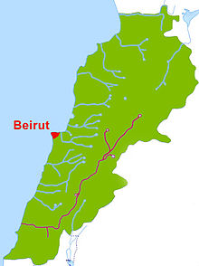
 The Litani River in maroon, the Lebanese capital city Beirut in red | |
| Location | |
| Country | Lebanon |
| Physical characteristics | |
| Mouth | Mediterranean Sea |
 | |

The Litani River (Arabic: نهر الليطاني, romanized: Nahr al-Līṭānī), the classical Leontes (‹See Tfd›Greek: Λεόντης, translit. Leóntes, lit. "lion river"), is an important water resource in southern Lebanon. The river rises in the fertile Beqaa Valley, west of Baalbek, and empties into the Mediterranean Sea north of Tyre. Exceeding 140 kilometres (87 mi) in length, the Litani is the longest river that flows entirely in Lebanon and provides an average annual flow estimated at 920 million cubic meters (over 240 million Imperial gallons or 243 U.S.gallons). [1][2] The Litani provides a major source for water supply, irrigation and hydroelectricity both within Southern Lebanon, and the country as a whole.
- ^ "LEBANON, Water resources". FAO UN. Archived from the original on 6 June 2015. Retrieved 4 November 2019.
- ^ "The Characteristics of the Litani River". The Litani River Authority. Archived from the original on 5 October 2018. Retrieved 4 November 2019.