Back M18 motorway German آزادراه ام۱۸ (بریتانیا) Persian Motorway M18 Italian Autostrada M18 (Gran Bretagna) LMO M18 (Groot-Brittannië) Dutch M18 motorway (Great Britain) SIMPLE M18 (Storbritannien) Swedish Автомагістраль M18 (Велика Британія) Ukrainian
| M18 | ||||
|---|---|---|---|---|
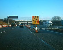
 Looking south near Rawcliffe | ||||
| Route information | ||||
| Part of | ||||
| Maintained by National Highways | ||||
| Length | 26.5 mi (42.6 km) | |||
| Existed | 1967–present | |||
| History | Opened: 1967 Completed: 1979 | |||
| Major junctions | ||||
| South-west end | Thurcroft 53°22′52″N 1°16′43″W / 53.3811°N 1.2785°W | |||
M1 motorway A1(M) motorway M180 motorway M62 motorway | ||||
| North-east end | Rawcliffe 53°40′57″N 0°58′03″W / 53.6825°N 0.9676°W | |||
| Location | ||||
| Country | United Kingdom | |||
| Counties | South Yorkshire, East Riding of Yorkshire | |||
| Primary destinations | Doncaster | |||
| Road network | ||||
| ||||


The M18 is a motorway in Yorkshire, England. It runs from the east of Rotherham to Goole and is approximately 26 miles (42 km) long. A section of the road forms part of the unsigned Euroroute E13.


