Back مقاطعة ماديرا (كاليفورنيا) Arabic Madera qraflığı (Kaliforniya) Azerbaijani Madera County, Kalifornien BAR Мадера (окръг) Bulgarian মাডেরা কাউন্টি, ক্যালিফোর্নিয়া BPY Мадера (гуо, Калифорни) CE Madera County CEB Madera County Czech Madera County, Califfornia Welsh Madera County Danish
Madera County | |
|---|---|
| County of Madera | |
|
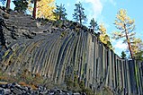
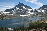
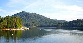
Images, from top down, left to right: Wassama Round House State Historic Park, Devils Postpile National Monument, Fresno Dome, Banner Peak above Thousand Island Lake, Bass Lake | |
 Interactive map of Madera County | |
 Location in the state of California | |
| Country | United States |
| State | California |
| Regions | San Joaquin Valley, Sierra Nevada |
| Metropolitan area | Metropolitan Fresno |
| Incorporated | 1893 |
| Named for | Spanish word meaning "wood" |
| County seat | Madera |
| Largest city | Madera |
| Government | |
| • Type | Council–CAO |
| • Body | Board of Supervisors |
| • Chair | David Rogers |
| • Chair Pro Tem | Robert L Poythress |
| • Board of Supervisors[1] | Supervisors
|
| • County Administrative Officer | Jay Varney |
| Area | |
| • Total | 2,153 sq mi (5,580 km2) |
| • Land | 2,137 sq mi (5,530 km2) |
| • Water | 16 sq mi (40 km2) |
| Highest elevation | 13,143 ft (4,006 m) |
| Population (2020) | |
| • Total | 156,255 |
| • Density | 73/sq mi (28/km2) |
| GDP | |
| • Total | $7.738 billion (2022) |
| Time zone | UTC−8 (Pacific Time Zone) |
| • Summer (DST) | UTC−7 (Pacific Daylight Time) |
| FIPS code | 06-039 |
| GNIS feature ID | 277284 |
| Congressional districts | 5th, 13th |
| Website | www |
Madera County (/məˈdɛərə/ ), officially the County of Madera, is a county located at the geographic center of the U.S. state of California.[3] It features a varied landscape, encompassing the eastern San Joaquin Valley and the central Sierra Nevada, with Madera serving as the county seat.[4] Established in 1893 from part of Fresno County, Madera County reported a population of 156,255 in the 2020 census.[5]
"Madera," meaning "wood" in Spanish, signifies the county's historical ties to the lumber industry.[6] With a section of Yosemite National Park within its borders, Madera County has leveraged tourism as a key economic driver. Additionally, it has established itself as a leading agricultural center, renowned for its substantial production of almonds, grapes, and pistachios. Despite these economic advantages, Madera County encounters socioeconomic challenges, including a median household income that falls below the California average and poverty rates that exceed state averages, underscoring the economic disparities within the county.[7]
Madera County is characterized by its diverse population, including a pronounced Native American heritage and a history of immigration and migration dating back to the California Gold Rush. The county has a 59.6% Hispanic or Latino population and 20.3% of residents are foreign-born, both percentages surpassing the national averages. Additionally, nearly half of Madera County's population speaks a language other than English at home, reflecting its multicultural composition.[8]
- ^ "Board of Supervisors | Madera County".
- ^ "Total Gross Domestic Product for Madera, CA (MSA)". Federal Reserve Economic Data. Federal Reserve Bank of St. Louis.
- ^ "California Geography". NETSTATE. Retrieved March 1, 2010.
- ^ "Find a County". National Association of Counties. Retrieved June 7, 2011.
- ^ "Madera County, California". United States Census Bureau. Retrieved January 30, 2022.
- ^ "How Counties In State Got Their Names". Santa Ana Journal. October 21, 1935. Retrieved February 12, 2024.
- ^ "Madera County, California". United States Census Bureau. Retrieved February 12, 2024.
- ^ "Madera County, California". United States Census Bureau. Retrieved February 12, 2024.


