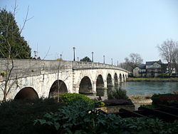
Maidenhead Bridge | |
|---|---|
 Maidenhead Bridge in 2011 | |
| Coordinates | 51°31′26″N 0°42′07″W / 51.5239°N 0.7019°W |
| Carries | A4 road, Thames Path |
| Crosses | River Thames |
| Locale | Maidenhead, Berkshire |
| Characteristics | |
| Design | Arch |
| Material | Stone |
| Height | 18 ft 7 in (5.66 m)[1] |
| No. of spans | 13 |
| Piers in water | 5 |
| History | |
| Designer | Robert Taylor |
| Opened | 1777 |
| Statistics | |
| Toll | Abolished 1903 |
| Location | |
 | |
Maidenhead Bridge is a Grade I listed bridge[2] carrying the A4 road over the River Thames between Maidenhead, Berkshire and Taplow, Buckinghamshire, England. It crosses the Thames on the reach above Bray Lock, about half a mile below Boulter's Lock. The Thames Path crosses the river here.
- ^ River Thames Alliance. Bridge heights on the River Thames.
- ^ Historic England. "Maidenhead Bridge (Grade II*) (1117619)". National Heritage List for England. Retrieved 27 July 2014.
