Back جبل مانجيرتون ARZ Mangerton Mountain CEB کوه منگرتون Persian Mangerton French Monte Mangerton Italian Mangerton Mountain LLD Mangerton Mountain NN Mangerton Mountain Swedish
| Mangerton (and Mangerton Mountain Group) | |
|---|---|
| An Mhangarta | |
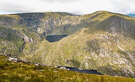
 Mangerton (c) with the hanging lake of Lough Erhogh (c) and Mangerton North Top (r) | |
| Highest point | |
| Elevation | 838.2 m (2,750 ft)[1] |
| Prominence | 583 m (1,913 ft)[1] |
| Listing | Marilyn, Hewitt, Arderin, Simm, Vandeleur-Lynam |
| Coordinates | 51°58′13″N 9°29′04″W / 51.970308°N 9.484395°W[1] |
| Naming | |
| English translation | long haired (mountain) |
| Language of name | Irish |
| Geography | |
| Location | County Kerry, Republic of Ireland |
| Parent range | Mangerton Mountain Group |
| OSI/OSNI grid | V980807 |
| Topo map | OSi Discovery 78[1] |
| Geology | |
| Rock age | Devonian[1] |
| Mountain type | Green sandstone & purple siltstone[1] |
| Climbing | |
| Easiest route | Devil's Punchbowl |
Mangerton or Mangerton Mountain (Irish: An Mhangarta, meaning 'the long-haired (mountain)'), at 838 metres (2,749 ft), is the 19th-highest peak in Ireland on the Arderin list, and the 26th–highest mountain according to the Vandeleur-Lynam list. Mangerton is the tallest mountain in the Mangerton Mountain Group, also called the Mangerton Mountains or the Mountains of East Kerry, a range that includes five other major mountains that have a height above 2,000 feet (610 m). Mangerton's western slopes lie within the Killarney National Park. On Mangerton's north-western face lies a deep corrie lake called the Devil's Punchbowl, which is a popular scenic destination for hill walkers; although the mountain is often overlooked by walkers due to the proximity of its more scenic and accessible neighbour, Torc Mountain. The far northern slopes of Mangerton was the site of an important 13th-century battle between the Mac Cárthaigh (Gaelic forces), and the FitzGeralds (Norman forces), known as the "Tooreencormick battle site".
- ^ a b c d e f "Mangerton Mountain". MountainViews Online Database. Retrieved 11 July 2019.
