Back سد مانجلا ARZ Mangla Dam (alihan sa tubig, lat 33,11, long 73,63) CEB Mangla-Talsperre German Mangla Akvobaraĵo Esperanto Presa de Mangla Spanish سد مانگله Persian Barrage de Mangla French मंगला बाँध Hindi മംഗള അണക്കെട്ട് Malayalam मंगला धरण Marathi
| Mangla Dam | |
|---|---|
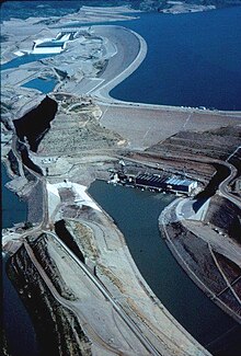
 Aerial photograph of the Mangla Dam, c. 2012 | |
| Country | Pakistan |
| Location | Mangla, Azad Kashmir Jhelum, Punjab[1] |
| Coordinates | 33°08′31″N 73°38′42″E / 33.142083°N 73.645015°E |
| Status | Operational |
| Construction began | 1961 |
| Opening date | 1967 |
| Construction cost | US$1.5 billion |
| Owner(s) | Government of Pakistan |
| Operator(s) | Water and Power Development Authority (WAPDA) |
| Dam and spillways | |
| Type of dam | Embankment dam |
| Impounds | Jhelum River |
| Height | 147 m (482 ft) |
| Length | 3,140 m (10,302 ft) |
| Reservoir | |
| Creates | Mangla Lake |
| Total capacity | 9.12 km3 (7,390,000 acre⋅ft) |
| Catchment area | 33,334 km2 (12,870 sq mi) |
| Surface area | 250 km2 (97 sq mi) |
| Power Station | |
| Turbines | 8 x 100 MW 2 x 135 MW |
| Installed capacity | 1,070 MW (operational) 1,310 MW (planned)[2] |
The Mangla Dam (Urdu: منگلا بند) is a multipurpose dam situated on the Jhelum River, lying in the Mirpur District of Azad Kashmir and the Jhelum District in Punjab, Pakistan.[1][3] It is the sixth-largest dam in the world. The village of Mangla, which sits at the mouth of the dam, serves as its namesake. In November 1961, the project's selected contractors were revealed; it was announced that Binnie & Partners, a British engineering firm, was going to serve as the lead designers, engineers, and inspectors for the construction of the dam (led by Geoffrey Binnie). The project was undertaken by a consortium known as the Mangla Dam Contractors,[4] which consisted of eight American construction firms sponsored by the Guy F. Atkinson Company based in South San Francisco, California.[5]
- ^ a b Kayani, Saheeb-Ahmed (19 July 2012). Mangla Dam Raising Project (Pakistan): General Review and Socio-Spatial Impact Assessment. Islamabad: National University of Sciences and Technology. hal-00719226.
- ^ "Mangla Refurbishment Project". nation.com.pk. 24 May 2022. Retrieved 20 July 2023.
- ^ Ali, Z.; Shelly, S. Y.; Bibi, F.; Joshua, G.; Khan, A. M.; Khan, B. N.; Akhtar, M. (2011). "Peculiarities of Mangla Reservoir: Biodiversity with sustainable use options" (PDF). The Journal of Animal and Plant Sciences. 21 (2 Suppl.): 372–380. ISSN 1018-7081.
- ^ Muir Wood, Sir Alan (1990). Biographical Memoirs of Fellows of the Royal Society: Geoffrey Morse Binnie (13 November 1908 – 5 April 1989). London: Royal Society. pp. 45–57.
- ^ Alvi, Hamid. "Two Years of Mangla Dam Project", Trade and Industry: The International Monthly Economic Journal of Pakistan. Spec. issue on Mangla Dam VIII.5 (1964): 633.
