Back Sistema nin Panlunad na Magian na Riles kan Manila BCL Metro de Manila Catalan Mass Rapid Transit Manila German Manila Light Rail Transit System Esperanto Sistema de Tránsito de Tren Ligero de Manila Spanish Manilako metroa Basque قطار سبک شهری مانیل Persian Métro léger de Manille French Sistem Angkutan Kereta Ringan Manila ID Metropolitana di Manila Italian
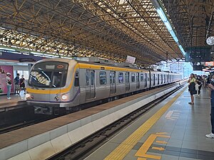
The Manila Light Rail Transit System, commonly known as the LRT, is an urban rail transit system that primarily serves Metro Manila, Philippines. Although categorized as a light rail system because it originally used light rail vehicles, it presently has characteristics of a rapid transit system, such as high passenger throughput, exclusive right-of-way, and later use of full metro rolling stock. The LRT is jointly-operated by the Light Rail Transit Authority (LRTA), a government corporation attached to the Department of Transportation (DOTr), and the Light Rail Manila Corporation (LRMC). Along with the Manila Metro Rail Transit System and the Metro Commuter Line of the Philippine National Railways, the system makes up Metro Manila's rail infrastructure.
The LRT's 43.5-kilometer-route (27.0 mi) is mostly elevated and consists of two lines and 38 stations. Line 1, also called the Green Line (formerly known as the Yellow Line), opened in 1984 and travels a north–south route. Line 2, the Blue Line (formerly, the Purple Line), was completed in 2004 and runs east–west. The original Line 1 was built as a no-frills means of public transport and lacks some features and comforts, but the newer Line 2 has been built with additional standards and criteria in mind like barrier-free access. In 2022, the system served 305,264 passengers on average.[1] Security guards at each station conduct inspections and provide assistance. A reusable plastic magnetic ticketing system has replaced the previous token-based system in 2001, and the Flash Pass was introduced as a step towards a more integrated transportation system. In 2015, the plastic magnetic tickets were replaced with the Beep, a contactless smart card, introduced to provide a common ticketing to 3 rail lines and some bus lines.
Many passengers who ride the system also take various forms of road-based public transport, such as buses and jeepneys, to and from a station to reach their intended destination. Although it aims to reduce traffic congestion and travel times in the metropolis, the transportation system has only been partially successful due to the rising number of motor vehicles and rapid urbanization. The network's expansion is set on resolving this problem.
- ^ a b Abadilla, Emmie V. (April 12, 2023). "10 regional airports up for sale - Bautista". Manila Bulletin. Retrieved April 13, 2023.
- ^ a b Light Rail Transit Authority (August 9, 2017). Maintenance of the Manila LRT Line 2 System, Terms of Reference (PDF) (Report). Light Rail Transit Philippines. Archived (PDF) from the original on June 12, 2020. Retrieved January 17, 2022.
- ^ a b Cite error: The named reference
jica2013study-1was invoked but never defined (see the help page).
Cite error: There are <ref group=lower-alpha> tags or {{efn}} templates on this page, but the references will not show without a {{reflist|group=lower-alpha}} template or {{notelist}} template (see the help page).


