Back Marble Hill, Manhattan Afrikaans Marble Hill Danish Marble Hill German Marble Hill (Nueva York) Spanish Marble Hill Estonian Marble Hill French Marble Hill, Manhattan ID Marble Hill (Manhattan) Italian 마블힐 (맨해튼) Korean Marble Hill (Manhattan) Dutch
Marble Hill | |
|---|---|
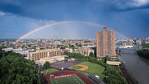
 An overview of Marble Hill seen from the west with John F. Kennedy High School (foreground) and the rest of Marble Hill (center) bound by the Harlem River (on right, the site of the Harlem Ship Canal), and The Bronx (background) | |
 | |
| Coordinates: 40°52′34″N 73°54′36″W / 40.876°N 73.91°W | |
| Country | |
| State | |
| City | New York City |
| Borough | Manhattan |
| Community District | Bronx 8[1] |
| Founded | 1891 |
| Named for | Local deposits of dolomitic marble quarried for federal buildings in lower Manhattan when New York was the capital of the United States in the 1780s. |
| Area | |
• Total | 0.38 km2 (0.145 sq mi) |
| Population | |
• Total | 9,481 |
| • Density | 25,000/km2 (65,000/sq mi) |
| Economics | |
| • Median income | $44,096 |
| ZIP Code | 10463 |
| Area code | 718/347/929, and 917 |
| Website | www |
Marble Hill is the northernmost neighborhood in the New York City borough of Manhattan. Although once part of Manhattan Island, it has been cut off from the island since 1817 and is part of the Continental United States. The Bronx surrounds the neighborhood to the west, north, and east, while the Harlem River is its southern border.
The area of Marble Hill became a Dutch colonial settlement in 1646. It served as a crossing point to the mainland when the colonial British had the King's Bridge constructed in 1693 to span the Spuyten Duyvil Creek. It gained its current name in 1891 from the Tuckahoe marble deposits discovered underneath the neighborhood.
Marble Hill was once the northernmost tip of the island of Manhattan.[4][5][6] The Spuyten Duyvil Creek flowed around the neighborhood to the north, separating Marble Hill from the Bronx, and by extension, the North American mainland. Marble Hill became an island in 1817, when two small streams were dug up to form a narrow canal. The waterway ran from the Spuyten Duyvil Creek to the Harlem River.[4][5][6][7][8][9]
The mill canal was expanded in 1895 to become the Harlem River Ship Canal. The new channel, constructed at the direction of the federal government, was 400 feet (120 m) wide and at least 15 feet (4.6 m) deep at its completion. Marble Hill remained an island until it was physically connected to the Bronx in 1913, when the old northern bend of the Spuyten Duyvil Creek was filled in.[4][6]
The boundaries of the neighborhood are approximately between Terrace View Avenue and Johnson Avenue to the west, between 228th Street and 230th Street to the north, and cutting through the Marble Hill Houses and River Plaza Shopping Center to the east.[10] It is connected to the rest of Manhattan by the Broadway Bridge.[11]
Because of this change in topography, Marble Hill is often associated with the Bronx and is part of Bronx Community District 8.[1] In addition, Marble Hill has a Bronx ZIP Code of 10463,[12] and is served by the New York City Police Department's 50th Precinct, headquartered in the Bronx.[13] Unlike the rest of Manhattan, it carries the Bronx area codes 718, 347, and 929, which are overlaid by the citywide area code 917.
- ^ a b "NYC Planning | Community Profiles". communityprofiles.planning.nyc.gov. New York City Department of City Planning. Retrieved June 6, 2018.
- ^ a b c "Marble Hill neighborhood in New York". Retrieved June 4, 2014.
- ^ a b "Marble Hill" Archived March 4, 2016, at the Wayback Machine on the Point2Homes website
- ^ a b c Tieck, William (1968). Riverdale, Kingsbridge, Spuyten Duyvil. Old Tappan, New Jersey: Fleming H. Revell Company. pp. 44–45.
- ^ a b Geismar, Joan (1984). "An Evaluation of the Archaeological Potential of the Community Hospital Site" (PDF).
- ^ a b c Eldredge, Niles; Horenstein, Sidney (2014). Concrete Jungle: New York City and Our Last Best Hope for a Sustainable Future (1 ed.). University of California Press. ISBN 978-0-520-27015-2. JSTOR 10.1525/j.ctt13x1gw7.
- ^ Engineers, United States Army Corps of (1875). Report of the Chief of Engineers U.S. Army. U.S. Government Printing Office. p. 233.
- ^ Kelley, Frank Bergen (1913). Historical Guide to the City of New York. New York: Frederick A. Stokes Company. p. 169.
- ^ Board of Supervisors, New York County (1860). "Document No. 16". Proceedings from July 1 to December 31, 1860. New York: J. H. Tobitt. p. 8.
- ^ "Manhattan, New York, NY" (Map). Google Maps. Retrieved March 27, 2020.
- ^ Lord, Anne W. "Marble Hill history literally is water under the bridge", Riverdale Press, August 3, 2018. Accessed January 8, 2024. "A pedestrian walks over the Broadway Bridge towards Manhattan from Marble Hill. The bridge passes over what was once known as the Harlem Ship Canal, which severed Marble Hill from the island of Manhattan, making it geographically a part of the Bronx, though to this day it remains politically a part of Manhattan."
- ^ Cite error: The named reference
zipmapswas invoked but never defined (see the help page). - ^ Cite error: The named reference
NYPD 50th Precinctwas invoked but never defined (see the help page).