Back مارينا دل راي (كاليفورنيا) Arabic مارينا دل راى, كاليفورنيا ARZ Marina del Rey Catalan Марина-дель-Рей (Калифорни) CE Marina del Rey CEB Marina del Rey German Marina del Rey (California) Spanish Marina del Rey (Kalifornia) Basque مارینا دل ری، کالیفرنیا Persian Marina del Rey French
Marina del Rey, California | |
|---|---|
 A north-to-east view from a boat slip in Marina del Rey's Basin E; Marina City Club is the left-most building, with the Ritz-Carlton Marina del Rey second from left. The photo depicts the original wood and canvas docks at Wayfarer Marina, which were replaced in 2019 by new concrete docks. | |
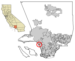
 Location within Los Angeles County | |
| Coordinates: 33°58′46″N 118°27′10″W / 33.97944°N 118.45278°W | |
| Country | |
| State | |
| County | |
| Area | |
• Total | 1.455 sq mi (3.768 km2) |
| • Land | 0.860 sq mi (2.226 km2) |
| • Water | 0.595 sq mi (1.541 km2) 40.91% |
| Elevation | 0 ft (0 m) |
| Population | |
• Total | 11,373 |
| • Density | 7,800/sq mi (3,000/km2) |
| Time zone | UTC-8 (Pacific (PST)) |
| • Summer (DST) | UTC-7 (PDT) |
| ZIP codes | 90291–90292, 90295 |
| Area code | 310/424 |
| FIPS code | 06-45806 |
| GNIS feature ID | 1852255 |

Marina del Rey (Spanish for "Marina of the King") is an unincorporated seaside community in Los Angeles County, California, with an eponymous harbor that is a major boating and water recreation destination of the Greater Los Angeles area. The port is North America's largest man-made small-craft harbor and is home to approximately 5,000 boats. The area is a popular tourism destination for both land and water activities such as paddle board and kayak rentals, dining cruises, and yacht charters. Land activities include bicycling on several bicycle paths, walking paths along the waterfront, and birdwatching (birding). Wildlife watching opportunities include California sea lions and harbor seals. Dolphins and whales occasionally visit the deeper waters of the harbor. This Westside locale is approximately 4 miles (6.4 km) south of Santa Monica, 4 miles (6.4 km) north of Los Angeles International Airport, and 12.5 miles (20.1 km) west-southwest of Downtown Los Angeles.
The harbor is owned by Los Angeles County and managed by the Department of Beaches and Harbors (DBH), but the waters are environmentally regulated by the state and the federal governments through their many agencies and departments with overlapping oversight. The Los Angeles Times in a 1997 editorial called the harbor "perhaps the county's most valuable resource."[4] The population was 11,373 at the 2020 census. For statistical purposes, the United States Census Bureau has defined Marina del Rey as a census-designated place (CDP).[5] The census definition of the area may not precisely correspond to local understanding of the area with the same name; for example, the 90292 ZIP code includes all of Marina del Rey and portions of neighboring Los Angeles, such as Del Rey, and has a population of 21,576,[6] more than double that of the CDP. Many residents of the 90292 ZIP code consider themselves to live in Marina del Rey even if they in fact live outside the official boundaries of the CDP.
- ^ "2010 Census U.S. Gazetteer Files – Places – California". United States Census Bureau.
- ^ "Marina del Rey". Geographic Names Information System. United States Geological Survey, United States Department of the Interior. Retrieved March 9, 2015.
- ^ "Marina Del Rey (CDP) QuickFacts". United States Census Bureau.
- ^ "Welcome Wave at the Marina". Editorial. Los Angeles Times. April 17, 1997.
- ^ "Marina del Rey Census Designated Place". Geographic Names Information System. United States Geological Survey, United States Department of the Interior.
- ^ Stats and Demographics for the 90292 ZIP Code. Retrieved July 29, 2021.


