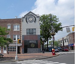
Maspeth | |
|---|---|
 Maspeth Federal Savings Bank | |
 Location within New York City | |
| Coordinates: 40°43′41″N 73°54′25″W / 40.728°N 73.907°W | |
| Country | |
| State | |
| City | New York City |
| County/Borough | Queens |
| Community District | Queens 5[3] |
| European settlement | 1642 |
| Founded by | Dutch settlers |
| Named for | Maspat Indians |
| Population | |
• Total | 30,516[1][2] |
| Ethnicity | |
| • White | 79.2% |
| • Hispanic | 7.6% |
| • Asian | 12.0% |
| • Black | 0.8% |
| • Other/Multiracial | 1.4% |
| Economics | |
| • Median income | $92,075 |
| Time zone | UTC– 05:00 (EST) |
| • Summer (DST) | UTC– 04:00 (EDT) |
| ZIP Code | 11378 |
| Area codes | 718, 347, 929, and 917 |
Maspeth is a residential and commercial community in the borough of Queens in New York City. It was founded in the early 17th century by Dutch and English settlers. Neighborhoods sharing borders with Maspeth are Woodside to the north; Sunnyside to the northwest; Greenpoint, Brooklyn to the west; East Williamsburg, Brooklyn to the southwest; Fresh Pond and Ridgewood to the south; and Middle Village and Elmhurst to the east.
Maspeth is located in Queens Community District 5 and its ZIP Code is 11378.[3] It is patrolled by the New York City Police Department's 104th Precinct.[6] Politically, Maspeth is represented by the New York City Council's 29th and 30th districts.[7]
- ^ Cite error: The named reference
PLP5was invoked but never defined (see the help page). - ^ a b c Data Access and Dissemination Systems (DADS). "U.S. Census website". census.gov.
- ^ a b "NYC Planning | Community Profiles". communityprofiles.planning.nyc.gov. New York City Department of City Planning. Retrieved April 7, 2018.
- ^ Cite error: The named reference
PLP3Awas invoked but never defined (see the help page). - ^ a b "Maspeth, New York, NY Population & Demographics". AreaVibes.
- ^ Cite error: The named reference
NYPD 104th Precinctwas invoked but never defined (see the help page). - ^ Current City Council Districts for Queens County, New York City. Accessed May 5, 2017.
