Back Avenida Massachusetts (Washington D. C.) Spanish خیابان ماساچوست (واشینگتن، دی.سی.) Persian Massachusetts Avenue Dutch میساچوسٹس ایونیو (واشنگٹن، ڈی سی) Urdu 马萨诸塞大道 Chinese
| Massachusetts Avenue SE Massachusetts Avenue NE Massachusetts Avenue NW | |
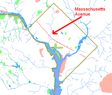
 Massachusetts Avenue's route map | |
| Maintained by | DDOT |
|---|---|
| Width | 160 feet (49 m) |
| Location | Washington, D.C., U.S. |
| Coordinates | 38°54′50″N 77°3′11″W / 38.91389°N 77.05306°W |
| East end | Southern Avenue |
| Major junctions | |
| West end | Westmoreland Circle |
| Construction | |
| Completion | 1871 |
 | |
Massachusetts Avenue Historic District | |
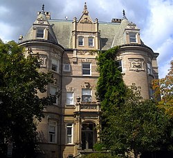
 Miller House, a contributing property to the Massachusetts Avenue Historic District | |
| Location | Both sides of Massachusetts Avenue between 17th Street and Observatory Circle, NW |
|---|---|
| Coordinates | 38°54′50″N 77°3′11″W / 38.91389°N 77.05306°W |
| Area | 81 acres (33 ha) |
| Built | 1871 |
| Architect | Multiple |
| Architectural style | Late Victorian, Beaux Arts |
| NRHP reference No. | 74002166[1] |
| Added to NRHP | October 22, 1974 |
Massachusetts Avenue is a major diagonal transverse road in Washington, D.C., and the Massachusetts Avenue Historic District is a historic district that includes part of it.
Massachusetts Avenue was part of Pierre Charles L'Enfant's original plan for the development of Washington, D.C. The avenue crosses three of Washington, D.C.'s four quadrants.[2] It intersects every major north–south street and passes numerous Washington landmarks. Massachusetts Avenue represents the northern boundary of downtown and the city's Embassy Row.
Massachusetts Avenue is tied with Pennsylvania Avenue as the widest road in Washington, D.C., at 160 feet (49 m). The two roads run in parallel through much of the city, Massachusetts about seven blocks north of Pennsylvania Avenue. Massachusetts Avenue was long considered the city's premier residential street, and Pennsylvania Avenue was its most sought-after business address. The two avenues are named Massachusetts and Pennsylvania, two states that played a leading role in securing American independence in the American Revolution and the subsequent Revolutionary War.
The historic district is an 81-acre (33 ha) area in Northwest Washington, D.C. that includes 150 contributing buildings and three contributing structures. In 1985, Massachusetts Avenue was listed on the National Register of Historic Places. It includes multiple properties that are individually listed on the National Register.[1]
- ^ a b "National Register Information System". National Register of Historic Places. National Park Service. March 13, 2009.
- ^ L'Enfant identified himself as "Peter Charles L'Enfant" during most of his life, while residing in the United States. He wrote this name on his "Plan of the city intended for the permanent seat of the government of t(he) United States ...." Archived 2016-01-11 at the Wayback Machine (Washington, D.C.) and on other legal documents. However, during the early 1900s, a French ambassador to the United States, Jean Jules Jusserand, popularized the use of L'Enfant's birth name, "Pierre Charles L'Enfant". (Reference: Bowling, Kenneth R. (2002). Peter Charles L'Enfant: Vision, Honor, and Male Friendship in the Early American Republic. George Washington University, Washington, D.C. ISBN 978-0-9727611-0-9). The United States Code states in 40 U.S.C. 3309 Archived 2021-04-02 at the Wayback Machine: "(a) In General.—The purposes of this chapter shall be carried out in the District of Columbia as nearly as may be practicable in harmony with the plan of Peter Charles L'Enfant." The National Park Service identifies L'Enfant as Major Peter Charles L'Enfant Archived 2014-04-05 at the Wayback Machine and as Major Pierre (Peter) Charles L'Enfant Archived 2010-04-03 at the Wayback Machine on its website.
